1877 Aufrufe | Öffentlich | Niederländisch
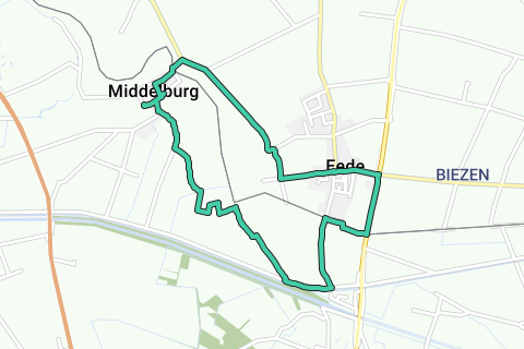
Near the border with the Netherlands, in the green creek area of North-East Flanders, rural Middelburg is hidden. Today Middelburg is a borough of Maldegem, but more than 500 years ago it was a real city! We explore the region around the Leopold Canal and cross the border to the Dutch Eede at border post 349.
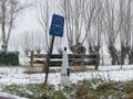
1. Appointment in Middelburg, in the Sint Jacobsstraat, at the rear of the late Gothic St. Peter and Paul Church (V). At the bus stop we take the footpath. Walk around the church with its remarkable celebration tower and you will find the entrance door to a moody prayer chapel with Lourdes grotto. In front of a calvary group in terracotta lies the tomb of politician and canon Jozef Andries. After the independence of Belgium, he wanted to put an end to the swamp fever that plagued the Meetjesland. In Brussels, he advocated the construction of the Leopold Canal to ensure better drainage. We encounter the canal on the way. In the church there is a funerary monument for Pieter Bladelin, the founder of Middelburg, but the church is usually locked, except during Sunday mass and from Thursday to Sunday during the holiday months.
2. When you leave the cemetery in front, walk to the left. At the end of the Middelburgse Kerkstraat you come to a pillory. On the other side of the road, at a pump, a young linden tree honours the cooperation between East Flanders, Zeeland and West Flanders in the field of nature. Turn right into Kloosterstraat. This leads to the Kasteelstraat. For a moment you enter this cul-de-sac with subdivision to the site of the disappeared castle of Middelburg (1). It was built in the 15th century by Pieter Bladelin, a wealthy Bruges porter in the service of Philip the Good and Charles the Bold. Now sheep graze there. From the unevenness of the terrain you can imagine that there was once a castle here. An information board and a bluestone column of explanation.
3. We return on our steps to the Kloosterstraat, turn right and take the first street on the left, the Schorreweg. At the height of the football field, take the Eedsche Kerkwegel (2) on the left. The white-red color marking reveals that it is part of one of the Great Route Paths. This is where the GR 5A North Antwerp-Ostend passes by. The signage is fine. She guides you between meadows and fields. On the horizon are the towers of Middelburg, Aardenbrug and Eede. Fluttering partridges and ducks come to say hello to you. At a first fork, continue to follow the GR marker and junction 52 on the left. You cross a ditch a few times and on a wide semi-paved road, the Waaktdijk (3), you turn right (those who want to shorten go straight ahead here and follow junction 52) in the direction of rows of slender poplars. They sailed two parallel sailings. The densest is the Leopold Canal, the furthest the Diversion Canal of the Lys. Follow the road to the left and take the Fortuinstraat 500 meters further left.
4. At border post 349 (4) choose the Grenspad, turn right. The paved path runs right on the border and leads to border post 348 on the Maldegem-Aardenburg road. You don't have to suffer thirst, on the right on Belgian territory is café 't Eerste Huis (5) and left on our walk restaurant-tearoom De Grens. They were once both customs posts and yet there was smuggling! Especially butter, gold and silver coins, cattle and... manure. The next crossroads makes the liberation unforgettable with a tank and a monument to Queen Wilhelmina, who entered the Netherlands from England via Eede in 1945 (6). You turn into the Brieversstraat and reach the center of Eede, 'd'Ee' in the local dialect.
5. At the church (7) there is a monument that evokes the flax past of the municipality. You return for a while and continue the tour through the Verloren Dorpweg and turn right at the Nieuwe Weg. On the corner is camping farm Spitsbroek (8). From the next intersection, follow direction Middelburg. Reeds and other upright greenery at some distance reveal that there is a creek there, on the left the Meulekreek, on the right the Biesput. At the intersection with the Krakeelweg there is a former tram station with customs mail (9) on the left. There you turn left and you step along a strip of dike. Also at the next intersection turn left. You will pass café-restaurant De Tol (10) and border post 352, with a beautiful view of the Meulekreek on the left. Via the Rentestraat you will reach the starting point again.
Route navigieren in...
![]() RouteYou-App Öffnen
RouteYou-App Öffnen
Diese Werbung nicht mehr anzeigen?
→ Jetzt upgraden
![]()
Bitte warten Sie, die Navigation wird vorbereitet.
Sie können jetzt navigieren. Viel Routen-Spaß!
Bearbeitung Ihrer Anfrage ist fehlgeschlagen. Bitte versuchen Sie es erneut.
Diese Werbung nicht mehr anzeigen?
→ Jetzt upgraden
![]()
Bitte warten Sie, Ihr Download wird vorbereitet.
Ihr Download ist fertig. Viel Routen-Spaß!
Bearbeitung Ihrer Anfrage ist fehlgeschlagen. Bitte versuchen Sie es erneut.
Diese Werbung nicht mehr anzeigen?
→ Jetzt upgraden
![]()
Bitte warten Sie, Ihr Ausdruck wird vorbereitet.
Ihr Ausdruck ist bereit für den Download. Viel Routen-Spaß!
Bearbeitung Ihrer Anfrage ist fehlgeschlagen. Bitte versuchen Sie es erneut.
Diese Werbung nicht mehr anzeigen?
→ Jetzt upgraden
![]()
Bitte warten Sie, Ihr Download wird vorbereitet.
Ihr Download ist fertig. Viel Routen-Spaß!
Bearbeitung Ihrer Anfrage ist fehlgeschlagen. Bitte versuchen Sie es erneut.
<iframe src="https://plugin.routeyou.com/routeviewer/free/?language=de&params.route.id=5346768&params.language=en" width="100%" height="600" frameborder="0" allowfullscreen></iframe>
<a href="https://www.routeyou.com/en-be/route/view/5346768/recreational-walking-route/between-middelburg-and-eede?utm_source=embed&utm_medium=article&utm_campaign=routeshare" title="Between Middelburg and Eede - RouteYou" target="_blank"><img src="https://image.routeyou.com/embed/route/960x670/5346768-en@2x.png" width="960" height="670" alt="Between Middelburg and Eede"></a>
Zusätzliches Feedback:
Probieren Sie diese Funktionalität kostenlos mit einem RouteYou Plus-Probeabonnement.
Wenn Sie bereits ein solches Konto haben, melden Sie sich jetzt an.
Probieren Sie diese Funktionalität kostenlos mit einem RouteYou Premium-Probeabonnement.
Wenn Sie bereits ein solches Konto haben, melden Sie sich jetzt an.
© 2006-2024 RouteYou - www.routeyou.com