869 Aufrufe | Öffentlich | Französisch • Niederländisch
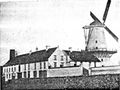
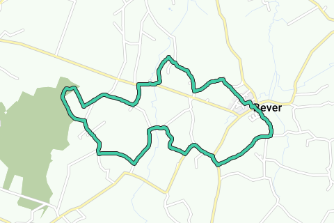
Meet at the place in Beaver. For GPS in the car, enter Bever center. Bever is a municipality located in the southwestern south-west of the Belgian province of Flemish Brabant and the only municipality in Belgium that does not name streets individually, but works with neighborhood names. All the streets near the church are therefore called Square. There is plenty of parking space. Start on the square next to the Sint-Martinuskerk and walk down the narrow street between house numbers 58 and 60 on the other side of the square and the large alley. After 100 meters, turn right along the paved track and 500 meters further you will arrive at a T-junction. On the left is a large and old brick farmhouse with a small white chapel against the façade. Walk right and after 50 meters at the junction straight next to the football field and the canteen of the Excelsior Bever. The asphalt track will soon become a wide dirt road and will take you into the open field. At an intersection of country roads, walk straight and 600 metres further to the right T-junction (carefully) along the main road, the N263.
After 150 meters on the left is a chapel with the year 1854. From there, turn left towards Lessen. Ignore an exit on the left and a little further you have a large white building 'La Bergerie' on the right. Immediately after, join the fork on the left and stay on the wider concrete track. After the fork, turn right for 250 meters on a narrow concrete road (sign towards exit 512 of the Pajottenland hiking network). You can see for miles in a green and quiet panorama. After 650 meters at exit 512, ignore the exit of exit 511 and continue straight towards exit 513 (Wandelnetwerk Pajottenland). After 250 meters you will arrive at exit 513.
If you want to shorten the walk to about 7.5 km, turn right towards exit 514 and join the larger loop.
If you are making the long loop, continue straight on exit 513. After 700 meters you will pass a large farm. Turn right immediately after the farm onto a wide field road. This will take you back to an asphalt track after 650 meters. Turn right. You are now walking here for a few hundred meters on and along the language border. On the left Wallonia, on the right Flanders. Leave Notre Dame Street and walk straight towards exit 506 of the Pajottenland hiking network. After 350 meters, ignore a right turn and turn left for another 250 meters on a country road still towards exit 506. The country road takes you first and then into the forest. After 100 meters in the forest, you are at exit 506. Walk to the right and go up to exit 515. After 200 meters and a right turn, you leave the forest again and after half a kilometer and a right-angle turn to the left, you return to the concrete track, still towards exit 515. At exit 515, continue straight towards exit 514. The church on the left is the Sint-Gereonkerk of Akrenbos, a hamlet of Bever. At exit 514, turn left onto exit 508.
The shortened walk again joins the longest loop at junction 514
After 400 meters, walk right at the T-junction and turn left 300 meters further towards Bloemendael. The road rises considerably and the views are again miles wide. After a right-angle turn, ignore the right exit and a little further the left exit and continue straight towards exit 510. After 600 metres at exit 510, turn left onto exit 5. After 500 meters you have a right angle turn and another left turn 150 meters further. In this last bend, walk straight on a narrow path between fence and field, always towards exit 5. At the end of the path, turn right for a while, then go down to the asphalt track. Go down to the left, ignore the first exit on the right and at the second exit go right and by a small staircase to the church. On the other side of the church is the square and the starting point.
Route navigieren in...
![]() RouteYou-App Öffnen
RouteYou-App Öffnen
Diese Werbung nicht mehr anzeigen?
→ Jetzt upgraden
![]()
Bitte warten Sie, die Navigation wird vorbereitet.
Sie können jetzt navigieren. Viel Routen-Spaß!
Bearbeitung Ihrer Anfrage ist fehlgeschlagen. Bitte versuchen Sie es erneut.
Diese Werbung nicht mehr anzeigen?
→ Jetzt upgraden
![]()
Bitte warten Sie, Ihr Download wird vorbereitet.
Ihr Download ist fertig. Viel Routen-Spaß!
Bearbeitung Ihrer Anfrage ist fehlgeschlagen. Bitte versuchen Sie es erneut.
Diese Werbung nicht mehr anzeigen?
→ Jetzt upgraden
![]()
Bitte warten Sie, Ihr Ausdruck wird vorbereitet.
Ihr Ausdruck ist bereit für den Download. Viel Routen-Spaß!
Bearbeitung Ihrer Anfrage ist fehlgeschlagen. Bitte versuchen Sie es erneut.
Diese Werbung nicht mehr anzeigen?
→ Jetzt upgraden
![]()
Bitte warten Sie, Ihr Download wird vorbereitet.
Ihr Download ist fertig. Viel Routen-Spaß!
Bearbeitung Ihrer Anfrage ist fehlgeschlagen. Bitte versuchen Sie es erneut.
<iframe src="https://plugin.routeyou.com/routeviewer/free/?language=de&params.route.id=5029377&params.language=en" width="100%" height="600" frameborder="0" allowfullscreen></iframe>
<a href="https://www.routeyou.com/en-be/route/view/5029377/recreational-walking-route/explore-pajottenland-from-bever?utm_source=embed&utm_medium=article&utm_campaign=routeshare" title="Explore Pajottenland from Bever - RouteYou" target="_blank"><img src="https://image.routeyou.com/embed/route/960x670/5029377-en@2x.png" width="960" height="670" alt="Explore Pajottenland from Bever"></a>
Zusätzliches Feedback:
Probieren Sie diese Funktionalität kostenlos mit einem RouteYou Plus-Probeabonnement.
Wenn Sie bereits ein solches Konto haben, melden Sie sich jetzt an.
Probieren Sie diese Funktionalität kostenlos mit einem RouteYou Premium-Probeabonnement.
Wenn Sie bereits ein solches Konto haben, melden Sie sich jetzt an.
© 2006-2024 RouteYou - www.routeyou.com