1207 Aufrufe | Öffentlich | Niederländisch
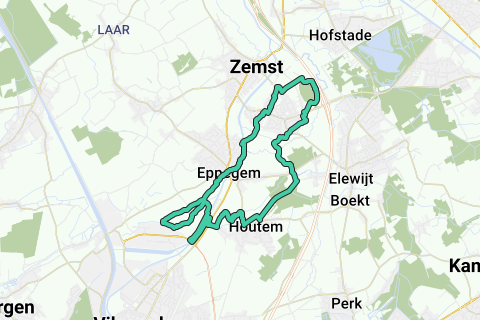
Weerde 10 miles (16,09km) over Dorent-Nelebroek and the Bomputten.
You can start at any other point of the loop according to your preference. Useful loop for long walkers, 10 miles endurance runners or recreational cyclists.
The special thing about this loop is that it only goes for 30% (less than 5km) along low-traffic / free asphalt roads, and for the remaining 70% along mainly paved but also unpaved paths. 10 miles in nature, thanks to Natuurpunt! Delicious!
The recent mouth of the Maelbeek into the Oude Zenne (Dorent) is addressed, closed Zennemeanders are passed (Nelebroek), as well as two historic WWII bomb pits along the Mechelen Vilvoorde railway line. Weerdemolen and Rubens Castle are also on the route.
There are 2 reductions suggested in the description.
Except in one location, the grass and weeds are normally mowed along the unpaved paths. That location is between the bomb pit meadow (zudelijk stuk, right next to the Vilvoorde Mechelen railway line) and the Damstraat on the border with Houtem. It is best to walk along the collecting streams, bordered by pollard willows, and use the correct crossings to bridge the collecting streams. In the last grove you keep the left flank (easily walkable), the last 15 meters you have to go a little more to the right in the grove to take the canal bridge to the Damstraat.
Short route description (the loop is drawn in a counterclockwise direction, starts at the church in Weerde):
-->Be careful when crossing schumanlaan. At the glass spheres of Weerde turn right, and at the fish pit also take right. Leave the fishing pit along the right side of the north car park, then follow the track bed to the left and take the second intersection on the right under the railway line.
-->Be careful when crossing Brusselsesteenweg in Eppegem: take the footpath on your left!
-->(Need shortening 1? Halfway down the Rekelstraat, take the bridge over the old Senne on the left.)
-->(in Dorent) At the end of the Rekelstraat continue in a southwesterly direction (first paved, then unpaved. Continue in the same direction for the last 30m (effe bumping) until the Maelbeek with collection water from the burnt bridge water treatment plant. Then follow the stream on your left until you cross the next concrete bridge. At that bridge there is the recent mouth (post-Cargo vil extension) of the Maelbeek in the old Senne. Follow the right bank of the water (Oude Zenne) in a northerly direction.
-->(need shortening 2? Do not follow the Oude Zenne, but take the bridge to the right, away from the water. This is the reverse Dorent walk. strongly discouraged without boots, the last part up to the Zennever discount is very soggy over long periods of the year and in winter these pants are regularly blank. In long dry weather in the summer, this shortening is not a problem.)
-->Take the first Oude Zennebrug back to the right and turn in a wide bend parallel to the Zennedijk shortening that becomes visible on your left. Continue on the left bank of the Zennedijk further southwest.
--> When returning north on the right bank of the Zennedijk, just after the motorcycle and moped shop De Schouwer, take the red asphalt bridge over the parallel stream, and return southwest and take the right side of the roundabout towards Houtem.
-->Immediately after the railway line, before the first house on the left, take a left towards bomb pits. A moment later you pass a bomb pit on your right, then on your left. A little further you come to a corner point of a southwestern and southeastern tree belt. There is a wooden bridge that takes you along the railway line to a third bomb pit. From there it is across the railway line into the field for the next two bomb pits and the crossing over a creek on the northeast side of the field.
Follow the pollard willows on the left until you take a second crossing over a creek. From there you follow the netted strip along the water on the left to the grove.
In the grove you keep left against the edge of the forest (wide walkable).
15m before you reach the Damstraat you leave the edge of the forest and go 10 steps more into the forest to the right, and then cross the canal on the Damstraat on the left over a concrete bridge. On the Damstraat turn right towards Houtem.
These pants are heavily overgrown with grass, sometimes with nettles and thistles, and have many collecting streams for drainage.
Natuurpunt has done a wonderful job here to make certain parts nettle-free and to maintain the bomb pits. So keep walking or cycling on the parts that have already been flattened. (This POI summarizes the route description along this: https://www.routeyou.com/location/view/47527294/bomputten-van-de-kluitingstraat-aan-de-spoorlijn-tot-de-damstraat.nl ).
--> In the first slight bend of the Damstraat (well before the roundabout) take the garden road (Brandvoetweg) on the left. In the end you have a few transverse trees where you notice that you have to turn right. At the end, take the Steenmolenweg on the left until you reach the Rubens Castle.
--> At the Rubens Castle take a left and on the T with the Rubenslaan you cross it and take the small forest path in the same northwest direction to the Oude Zenne. There on the right, across Weerdemolen, a take the first path back on the Senneberm to the first houses to the left of you. Take the cross path on the left 100 metres further. Cross the Damstraat diagonally left and take the Pastorijstraat which ends at the church. Your 10 miles have ended.
Route navigieren in...
![]() RouteYou-App Öffnen
RouteYou-App Öffnen
Diese Werbung nicht mehr anzeigen?
→ Jetzt upgraden
![]()
Bitte warten Sie, die Navigation wird vorbereitet.
Sie können jetzt navigieren. Viel Routen-Spaß!
Bearbeitung Ihrer Anfrage ist fehlgeschlagen. Bitte versuchen Sie es erneut.
Diese Werbung nicht mehr anzeigen?
→ Jetzt upgraden
![]()
Bitte warten Sie, Ihr Download wird vorbereitet.
Ihr Download ist fertig. Viel Routen-Spaß!
Bearbeitung Ihrer Anfrage ist fehlgeschlagen. Bitte versuchen Sie es erneut.
Diese Werbung nicht mehr anzeigen?
→ Jetzt upgraden
![]()
Bitte warten Sie, Ihr Ausdruck wird vorbereitet.
Ihr Ausdruck ist bereit für den Download. Viel Routen-Spaß!
Bearbeitung Ihrer Anfrage ist fehlgeschlagen. Bitte versuchen Sie es erneut.
Diese Werbung nicht mehr anzeigen?
→ Jetzt upgraden
![]()
Bitte warten Sie, Ihr Download wird vorbereitet.
Ihr Download ist fertig. Viel Routen-Spaß!
Bearbeitung Ihrer Anfrage ist fehlgeschlagen. Bitte versuchen Sie es erneut.
<iframe src="https://plugin.routeyou.com/routeviewer/free/?language=de&params.route.id=471481&params.language=en" width="100%" height="600" frameborder="0" allowfullscreen></iframe>
<a href="https://www.routeyou.com/en-be/route/view/471481/jogging-route/weerde-10mi-dorent-nelebroek-bomb-pits-16-09km?utm_source=embed&utm_medium=article&utm_campaign=routeshare" title="Weerde 10Mi Dorent-Nelebroek Bomb Pits (16,09km) - RouteYou" target="_blank"><img src="https://image.routeyou.com/embed/route/960x670/471481-en@2x.png" width="960" height="670" alt="Weerde 10Mi Dorent-Nelebroek Bomb Pits (16,09km)"></a>
Zusätzliches Feedback:
Probieren Sie diese Funktionalität kostenlos mit einem RouteYou Plus-Probeabonnement.
Wenn Sie bereits ein solches Konto haben, melden Sie sich jetzt an.
Probieren Sie diese Funktionalität kostenlos mit einem RouteYou Premium-Probeabonnement.
Wenn Sie bereits ein solches Konto haben, melden Sie sich jetzt an.
© 2006-2024 RouteYou - www.routeyou.com