3479 Aufrufe | Öffentlich | Französisch • Niederländisch
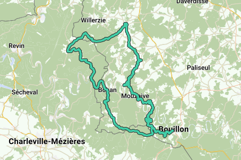
We climb along the N810 from the Semois valley. Seven kilometers to overcome 140 meters of altitude seems like a perfect warm-up and we should be able to fully enjoy the beautiful forests and views.
Entering Corbion, we turn left towards the France and cross the border a few kilometers further for the first time. We drive about five kilometers through La Douce France, then continue the N810 to Sugny. Just after Sugny, we turn right and cross the wood of Bohan to the village of the same name on the Semois. So we are 25 km away, have crossed the woods by bike all the time and are back on the banks of the Semois.
In Bohan we turn left and cross the bridge of the Semois to follow the river to a little further in France. In the village of Hautes-Rivières we turn right into Rue l'Inchamps to reach the highest point of our walk via a steep but beautiful climb through the forest about 13 km further at an altitude of 470 meters. Just before we turn right on the D989 to pedal a little further right towards the Vieux Moulins de Thilay. We continue in the village on the right towards the Franco-Belgian border even if we have to brave a forest road in very poor condition for 500 meters. Back in Belgium, we follow rue Marotelle and turn right a little further to pass the Millenium Tower of Gedinne with a steep climb. However, during the hunting season, this road may be closed. In this case, we drive a few kilometers to continue through Rue Marotelle to the village of Willerzie where you take the N952 on the right of Gedinne.
Outside the hunting season, we continue to follow the road along the Millennium Tower towards Gedinne until we connect with the Rando Vélo N°3 which takes us to Gedinne. There, we connect to the Rando Vélo N°2 which will take us back to Bouillon via Houdremont, Bellefontaine and Vresse-sur-Semois. The Rando Vélo are all marked with blue-yellow stripes on poles and trees.
Suitable for road cyclists and group cycle tourists.
Route navigieren in...
![]() RouteYou-App Öffnen
RouteYou-App Öffnen
Diese Werbung nicht mehr anzeigen?
→ Jetzt upgraden
![]()
Bitte warten Sie, die Navigation wird vorbereitet.
Sie können jetzt navigieren. Viel Routen-Spaß!
Bearbeitung Ihrer Anfrage ist fehlgeschlagen. Bitte versuchen Sie es erneut.
Diese Werbung nicht mehr anzeigen?
→ Jetzt upgraden
![]()
Bitte warten Sie, Ihr Download wird vorbereitet.
Ihr Download ist fertig. Viel Routen-Spaß!
Bearbeitung Ihrer Anfrage ist fehlgeschlagen. Bitte versuchen Sie es erneut.
Diese Werbung nicht mehr anzeigen?
→ Jetzt upgraden
![]()
Bitte warten Sie, Ihr Ausdruck wird vorbereitet.
Ihr Ausdruck ist bereit für den Download. Viel Routen-Spaß!
Bearbeitung Ihrer Anfrage ist fehlgeschlagen. Bitte versuchen Sie es erneut.
Diese Werbung nicht mehr anzeigen?
→ Jetzt upgraden
![]()
Bitte warten Sie, Ihr Download wird vorbereitet.
Ihr Download ist fertig. Viel Routen-Spaß!
Bearbeitung Ihrer Anfrage ist fehlgeschlagen. Bitte versuchen Sie es erneut.
<iframe src="https://plugin.routeyou.com/routeviewer/free/?language=de&params.route.id=1254757&params.language=en" width="100%" height="600" frameborder="0" allowfullscreen></iframe>
<a href="https://www.routeyou.com/en-be/route/view/1254757/road-bike-route/from-bouillon-via-the-france-to-gedinne-and-back?utm_source=embed&utm_medium=article&utm_campaign=routeshare" title="From Bouillon via the France to Gedinne and back - RouteYou" target="_blank"><img src="https://image.routeyou.com/embed/route/960x670/1254757-en@2x.png" width="960" height="670" alt="From Bouillon via the France to Gedinne and back"></a>
Zusätzliches Feedback:
Probieren Sie diese Funktionalität kostenlos mit einem RouteYou Plus-Probeabonnement.
Wenn Sie bereits ein solches Konto haben, melden Sie sich jetzt an.
Probieren Sie diese Funktionalität kostenlos mit einem RouteYou Premium-Probeabonnement.
Wenn Sie bereits ein solches Konto haben, melden Sie sich jetzt an.
© 2006-2024 RouteYou - www.routeyou.com