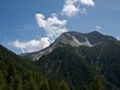
An incredible panorama route which takes you to Europe's largest erosion site 'Illgraben' and spectacular views over the Rhone valley.
Route:
This route starts in the village of Chandolin, it's one of the highest villages of the Alps and is situated at 2000m above sea-level. Parking can be found above the tourist office in the center of the village.
From the tourisme Office we follow the main road to the old center of Chandolin and take the first road on the right. The road leads up and brings you at the border of the forest. Once arrived at a small parking lot under the trees, you leave the main road and go through the parking lot , at the end you'll find a small but very beautiful path into the forest.After 700 meters the path turns up the hill and back on a big gravel road where we go left.The road is very easy now with little difference in height and gives some nice views over the Rhone Valley.
After 2km you'll see a small path on the right which brings you on the Illgraben erosion site; the view here is really amazing.
From the Illgraben you'll go back to the main road where we continue in the direction of Ponchet, along the way you'll get more splendid views over the Illgraben erosion site. At Ponchet you can rest out a bit.
To make the hike more adventurous we turn left at Ponchet in the direction of Soussillon, a very small village below Chandolin that's worth a visit. From Soussillon awaits a good climb back to Chandolin where you go through the old part of the village that's very authentic.
Route difficulty: T2 - Mountain hike
My experience:
First hike of my three weeks in Switzerland. The hike started in Chandolin where we were staying. From there headed to the Illgraben, a very large erosion site. Weather was great but very warm, it made the hike a bit more heavy. After the Illgraben we where heading to Ponchet where we still had some nice views over the Illgraben. At Ponchet it was time to go way down to the lower village of Soussillon before heading back to Chandolin. Not that there was much to see in Soussillon but we wanted to end with a climb. So from Soussillon we headed back to Chandolin, a nice climb to end this journey.
Statistics:
Length: 12.5 km
Duration: 3 hours, 18 minutes, 14 seconds
Vertical up: 798.3 m
Vertical down: 767.1 m
Average Speed: 3.8 km/h
Navigeer de route met...
![]() RouteYou app Open
RouteYou app Open
Deze advertentie niet meer zien?
→ Upgrade nu
![]()
Even geduld, de navigatie wordt voorbereid.
Je kan nu navigeren. Veel plezier onderweg!
Het verwerken van de aanvraag is mislukt. Gelieve het opnieuw te proberen.
Deze advertentie niet meer zien?
→ Upgrade nu
![]()
Even geduld, je download wordt voorbereid.
Je download is klaar. Veel plezier onderweg!
Het verwerken van de aanvraag is mislukt. Gelieve het opnieuw te proberen.
Deze advertentie niet meer zien?
→ Upgrade nu
![]()
Even geduld, je afdruk wordt voorbereid.
Je afdruk is klaar om te downloaden. Veel plezier onderweg!
Het verwerken van de aanvraag is mislukt. Gelieve het opnieuw te proberen.
<iframe src="https://plugin.routeyou.com/routeviewer/free/?language=nl&params.route.id=2260494&params.language=en" width="100%" height="600" frameborder="0" allowfullscreen></iframe>
<a href="https://www.routeyou.com/en-ch/route/view/2260494/hiking-route/to-the-illgraben-erosion-site-and-soussillon?utm_source=embed&utm_medium=article&utm_campaign=routeshare" title="To the Illgraben erosion site and Soussillon - RouteYou" target="_blank"><img src="https://image.routeyou.com/embed/route/960x670/2260494-en@2x.png" width="960" height="670" alt="To the Illgraben erosion site and Soussillon"></a>
Bijkomende feedback:
Probeer deze functionaliteit gratis met een RouteYou Plus-proefabonnement.
Als je al een dergelijke account hebt, meld je dan nu aan.
Probeer deze functionaliteit gratis met een RouteYou Premium-proefabonnement.
Als je al een dergelijke account hebt, meld je dan nu aan.
© 2006-2024 RouteYou - www.routeyou.com