Bron: Johan N
Auteursrechten: Creative Commons 3.0
4125 keer bekeken | Publiek | Nederlands
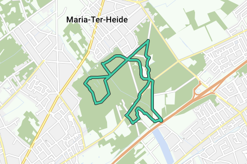
The common thread of this trip is the anti-tank ditch in Brasschaat, a 33 km long watercourse that had to stop the advance of the German tanks. For a while they wanted to make it a pusher, but that plan was cancelled. Now it is a long nature reserve where it is wonderful to walk through forest and heathland.
1. Appointment at the entrance of domain De Inslag (147 ha) and park De Mik in the Kerkedreef in Maria-ter-Heide. Walk into the Weft and immediately turn right. You can follow the blue arrows of the Brasschaat Antitank Path for a long time. There is no other way, because all other paths are forbidden for hikers or leave the domain.
2. Ignore a path on the right, walk 31 and at the first intersection turn left towards 83. At the end of this path you will see a sunbathing lawn with shelter and picnic table on the right. Turn right, cross the anti-tank channel and follow it to the right towards 84.
3. The anti-tank ditch was dug between 1937 and 1939 and runs from Zandvliet to Oelegem. This canal - 33 km long, in a quarter circle around Antwerp - was to stop the advance of the German tanks. But the enemy came from the other side... For a while they wanted to put a pusher canal over it, a plan that has now been removed. As a result, the canal is now a long nature reserve.
4. Stroll along the canal and, just past a bunker towards 88 and opposite a bridge, turn left; the LLL info panel. Continue to the crossroads. On the right there is a private road, right in front of you a beautiful beech drive, which you are not allowed to enter. So turn left. After a right-left nod, you continue to the next quadrangle. Continue straight ahead towards 83. On the left is a measuring station that records the concentration of sulphur dioxide, ozone and nitrogen compounds in the air.
5. At the next intersection you can only turn left. Step next to the picnic area and ignore all the side paths until you reach a wide lane. Turn left towards 83 and at the next intersection turn right. Following the anti-tank channel to the right is prohibited. So you have to walk out of the lane to the starting point.
6. But the walk is not over yet. Cross the Kerkedreef and walk into park De Mik. Keep following the blue signs, cross an intersection and walk over the drawbridge, through the impressive tower gate (1832). This is a copy of the Porte d'Auron in Bourges, France.
7. Continue walking along the pond and castle de Mik (1785) and cross a bridge. Turn right on the T. Keep following the path until you reach the red and white barrier. Cross the Zandbeek and the Miksebaan and follow the lane diagonally to the right on the other side. Walk straight on past the Buitenhof nursing home towards 12 until you reach the anti-tank canal. Turn left until you reach a small bridge. The anti-tank ditch passes under the railway embankment of the TGV and the highway. Cross the bridge. The blue path turns right. You walk another 300 m along the railway. Ignore a path that goes under the railroad and highway. 'Look' here diagonally to the right the 'bridge' over the canal. They are no more than a few concrete beams. Step over it and turn right. You now walk on a beautiful path, along the E10 lake, created during the construction of the E10 (now E19). After you have 'rounded' the top of the pond, you step a little further along the water. At the first opportunity you turn right, at the fork turn right, away from the puddle. Follow the asphalt road on the right. Ignore the Schomheide on the left and turn with the road to the right. At the end turn right. Walk carefully along the Mikse baan, which has quite a bit of traffic.
8. Cross the anti-tank channel and turn left into Kerkedreef. Turn immediately right into Park De Mik. Walk next to a moat of the park and follow the blue arrows again. You end up on the dolomite path, where you came earlier. On the right is the red and white barrier. So turn left. Leave the bridge and continue walking straight ahead. You arrive at a place with a view of the castle and the tower gate. Turn right here, to the Mikerf petting zoo (the tavern is closed on Mondays). Walk past the tavern to a roundabout. The blue walk turns left. You turn right. Turn the second lane to the right. There is a P. At the crossroads you turn left until you reach the starting point
Navigeer de route met...
![]() RouteYou app Open
RouteYou app Open
Deze advertentie niet meer zien?
→ Upgrade nu
![]()
Even geduld, de navigatie wordt voorbereid.
Je kan nu navigeren. Veel plezier onderweg!
Het verwerken van de aanvraag is mislukt. Gelieve het opnieuw te proberen.
Deze advertentie niet meer zien?
→ Upgrade nu
![]()
Even geduld, je download wordt voorbereid.
Je download is klaar. Veel plezier onderweg!
Het verwerken van de aanvraag is mislukt. Gelieve het opnieuw te proberen.
Deze advertentie niet meer zien?
→ Upgrade nu
![]()
Even geduld, je afdruk wordt voorbereid.
Je afdruk is klaar om te downloaden. Veel plezier onderweg!
Het verwerken van de aanvraag is mislukt. Gelieve het opnieuw te proberen.
Deze advertentie niet meer zien?
→ Upgrade nu
![]()
Even geduld, je download wordt voorbereid.
Je download is klaar. Veel plezier onderweg!
Het verwerken van de aanvraag is mislukt. Gelieve het opnieuw te proberen.
<iframe src="https://plugin.routeyou.com/routeviewer/free/?language=nl&params.route.id=5295244&params.language=en" width="100%" height="600" frameborder="0" allowfullscreen></iframe>
<a href="https://www.routeyou.com/en-be/route/view/5295244/recreational-walking-route/along-the-anti-tank-canal-in-maria-ter-heide?utm_source=embed&utm_medium=article&utm_campaign=routeshare" title="Along the anti-tank canal in Maria-ter-Heide - RouteYou" target="_blank"><img src="https://image.routeyou.com/embed/route/960x670/5295244-en@2x.png" width="960" height="670" alt="Along the anti-tank canal in Maria-ter-Heide"></a>
Bijkomende feedback:
Probeer deze functionaliteit gratis met een RouteYou Plus-proefabonnement.
Als je al een dergelijke account hebt, meld je dan nu aan.
Probeer deze functionaliteit gratis met een RouteYou Premium-proefabonnement.
© 2006-2024 RouteYou - www.routeyou.com