1752 keer bekeken | Publiek | Frans • Nederlands
Schorisse is probably one of the most remote villages in East Flanders. In the heart of the Flemish Ardennes, the village offers idyllic valleys and miles of panoramas. The ridges are wooded. This is where the streams that model the hilly landscape rise. In the fertile valleys, farmers plow in clay. No wonder you come across a nature reserve more than once along the way. Here you can discover fauna and flora that have long since migrated elsewhere in Flanders. So take your time.
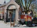
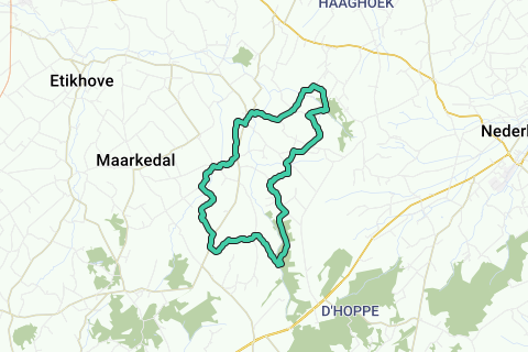
1. Head to St. Peter's Church in Schorisse, a district of Maarkedal. The church (late Gothic and classical) and its immediate surroundings are protected as a view of the village. Walk next to the church in the Essestraat. Immediately you will be overwhelmed by the vastness, greenery and tranquility of the Flemish Ardennes. The name Flemish Ardennes was first used by Omer Wattez, born here in Schorisse in 1857 and the first promoter of the region's tourist attractions. After 600 m, at a crossroads, turn left and at the next intersection go straight into Beekkantstraat. Past the St.-Kornelis-Horebeke nameplate, you suddenly walk down Steenstraat. On the right, you ignore the Weverbeekstraat. Straight ahead, there is a steep climb.
2. At house number 13, you enter directly into a field road. This is where your boots come in really handy. Enjoy the beautiful view of the picturesque Krombeek Valley. Once out of the country road, go straight into the forest. After 200 m you turn right onto the Krombeek and immediately afterwards you choose at the crossroads on the right. You cross the Burreken, a protected landscape of about 220 ha on the border of Schorisse, Horebeke and Zegelsem. Natuurpunt manages a nature reserve of the same name of about 30 ha. Dozens of sources indicate that the region has great differences in relief. The spring forests are also the ideal biotope for the fire salamander, since the seventies the symbol of nature conservation in the Flemish Ardennes. At the T-junction, you turn left towards Ganzenberg for another steep climb. Cross the Omer Wattezstraat and a little further you take the Stokstraat on the right. After 200 m, in front of house n°22, turn left. It quickly becomes a narrow (and often very dirty) road between the barbed wire. It takes you considerably to Steenbeek. Back on the paved road, you choose left and 100 m further at the crossroads for the right, go up into the Rijststraat. On the right you have a beautiful view of Maarkedal.
3. On the two-lane concrete road, turn left into Bosgatstraat. Ignore the Tiegstraat on the right, leave the Odevaertstraat a little later and walk 200 m further after house number 34 on the right in a paved road. This takes you a little further via a barrier into the forest of the Ter Rijst estate, a species-rich deciduous forest of about 22 ha with pedunculate oaks and ash trees as the main species. You will find the typical ground cover of an ancient forest such as forest anemone, wild hyacinth, periwinkle and valley grass but also the golden veil, the root of purple scales, the root of bacon and the rare giant horsetail. In '71, an action group prevented the sale of the forest to a private company. He wanted to build weekend houses there.
4. After 500 m and a right turn, you can choose at the crossroads: the two forest roads take you 300 m further to the same pair of benches under a thatched roof. 100 m further, you go down on the right and - once out of the forest on the Molenbeek - immediately straight. On the right you have a beautiful view of the Bos Ter Rijst and the Molenbeek valley. At the top of the intersection, continue straight on Kouterstraat. The paved road becomes unpaved, then the asphalt road returns. On the left, you pass in front of an old square farmhouse. Take a look at the imposing courtyard with a knife bullet ditto. Stay on the paved road and at the end of the Gielestraat turn right.
5. Leave the Goudberg and walk 250 m further left in front of an old farm building in the veldweg. Soon you are walking down a beautiful hollow road and you get one of the many wide views of Maarkedal. Ignore country roads on the left and turn right and later left. At the end of the Herpelstraat you walk to the right and 500 m further, at the end of the Markettestraat again turn right into the Leideveldstraat. In a left turn you follow the LF6 cycle path and the cycle exit 38 and after a final steep climb you take the Kolpaartstraat on the left. After the Schoolstraat, another right turn and one left and 300 m further, you are again at the church in Schorisse.
Navigeer de route met...
![]() RouteYou app Open
RouteYou app Open
Deze advertentie niet meer zien?
→ Upgrade nu
![]()
Even geduld, de navigatie wordt voorbereid.
Je kan nu navigeren. Veel plezier onderweg!
Het verwerken van de aanvraag is mislukt. Gelieve het opnieuw te proberen.
Deze advertentie niet meer zien?
→ Upgrade nu
![]()
Even geduld, je download wordt voorbereid.
Je download is klaar. Veel plezier onderweg!
Het verwerken van de aanvraag is mislukt. Gelieve het opnieuw te proberen.
Deze advertentie niet meer zien?
→ Upgrade nu
![]()
Even geduld, je afdruk wordt voorbereid.
Je afdruk is klaar om te downloaden. Veel plezier onderweg!
Het verwerken van de aanvraag is mislukt. Gelieve het opnieuw te proberen.
Deze advertentie niet meer zien?
→ Upgrade nu
![]()
Even geduld, je download wordt voorbereid.
Je download is klaar. Veel plezier onderweg!
Het verwerken van de aanvraag is mislukt. Gelieve het opnieuw te proberen.
<iframe src="https://plugin.routeyou.com/routeviewer/free/?language=nl&params.route.id=5295221&params.language=en" width="100%" height="600" frameborder="0" allowfullscreen></iframe>
<a href="https://www.routeyou.com/en-be/route/view/5295221/recreational-walking-route/ascent-and-descent-in-maarkedal?utm_source=embed&utm_medium=article&utm_campaign=routeshare" title="Ascent and descent in Maarkedal - RouteYou" target="_blank"><img src="https://image.routeyou.com/embed/route/960x670/5295221-en@2x.png" width="960" height="670" alt="Ascent and descent in Maarkedal"></a>
Bijkomende feedback:
Probeer deze functionaliteit gratis met een RouteYou Plus-proefabonnement.
Als je al een dergelijke account hebt, meld je dan nu aan.
Probeer deze functionaliteit gratis met een RouteYou Premium-proefabonnement.
© 2006-2024 RouteYou - www.routeyou.com