The city of Martigny is the starting point of this long climb of 30 kilometres that will surprise you with its incredibly diverse landscape. You start the day criss-crossing the vineyards before reaching the summit of the Col de la Forclaz in the middle of a larch forest. After a short descent through the town of Trient, you take a right turn off the main road to begin the second climb towards the dam. The ascent takes you through scenery worthy of the great Alpine passes. Feel free to refuel at Finhaut before the final climb to Emosson dam…it’s a tough one.
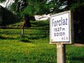
As you pedal through beautifully terraced vineyards, you realize how quickly you are gaining altitude as Martigny becomes smaller and smaller. You leave the grand view of the Rhone Valley once through the Col de la Forclaz (1,528m). Take time to stop and enjoy a delicious fruit tart at the Hotel du Col de la Forclaz, because you still have a long journey ahead. After this well-deserved break, you dive into another valley and pass the village of Trient. A turn off to the right takes you into Finhaut and the start of the second climb. The more you climb, the more the landscape becomes wild and magical. The dam only lets itself be seen at the last moment, once you have reached the summit of the Col de la Guelaz (1,965m). And once there, all of your efforts will be rewarded, as the view over the Mont Blanc and the Aiguilles du Tour is breath-taking. This impressive dam was built between 1969 and 1975, is the second largest dam in Switzerland and the third highest in Valais. When you are on top of the dam in spring, look deep down into the lake and you may see the remains of the Barberine Dam, built in 1925, which was submerged after the Emosson Dam was filled.
In autumn, the leaves on the larch trees turn magnificent shades of orange, blueberry leaves turn red, and the landscape becomes worthy of the finest Indian summers! Emotions guaranteed! It is absolutely spectacular!
Arrive in Martigny by train from all Swiss towns and cities (SBB) or by the regional trains Railway Mont-Blanc & St-Bernard Express.
Take the A9 Motorway exit E27 autoroute Martigny/Grand St. Bernard. At the roundabout, follow signs towards Col de la Forclaz / Chamonix (France)
Follow the car-park routeing in Martigny.
We recommend: bike in excellent working order, helmet, gloves and bell, clothing suitable for the weather (always carry a waterproof), food and drink.
Strictly respect the Swiss traffic rules. Please note that you are running the tour at your own risk and all liability is refused. Please be considerate to plants and animals.
Strictly respect the Swiss traffic rules. Please note that you are running the tour at your own risk and all liability is refused. Please be considerate to plants and animals.
Risorsa: Valais Wallis Promotion
Naviga nel percorso in...
![]() App RouteYou Aprire
App RouteYou Aprire
Vuoi smettere di vedere questo annuncio?
→ Upgrade ora
![]()
Attendi, la navigazione è in preparazione.
Ora puoi navigare. Buon divertimento in viaggio!
Elaborazione della richiesta non è riuscita. Si prega di riprovare.
Vuoi smettere di vedere questo annuncio?
→ Upgrade ora
![]()
Attendi, il tuo download è in preparazione.
Il tuo download è pronto. Buon divertimento in viaggio!
Elaborazione della richiesta non è riuscita. Si prega di riprovare.
Vuoi smettere di vedere questo annuncio?
→ Upgrade ora
![]()
Attendi, la tua stampa è in preparazione.
La tua stampa è pronta per il download. Buon divertimento in viaggio!
Elaborazione della richiesta non è riuscita. Si prega di riprovare.
<iframe src="https://plugin.routeyou.com/routeviewer/free/?language=it&params.route.id=5315464&params.language=en" width="100%" height="600" frameborder="0" allowfullscreen></iframe>
<a href="https://www.routeyou.com/en-ch/route/view/5315464/road-bike-route/emosson-trophy-of-the-dams-velo-in-martigny?utm_source=embed&utm_medium=article&utm_campaign=routeshare" title="Emosson - Trophy of the Dams Velo in Martigny - RouteYou" target="_blank"><img src="https://image.routeyou.com/embed/route/960x670/5315464-en@2x.png" width="960" height="670" alt="Emosson - Trophy of the Dams Velo in Martigny"></a>
Altri commenti:
Prova questa funzionalità gratuitamente con un abbonamento di prova RouteYou Plus.
Se hai già un tale account, accedi ora.
Prova questa funzionalità gratuitamente con un abbonamento di prova RouteYou Premium.
Se hai già un tale account, accedi ora.
© 2006-2024 RouteYou - www.routeyou.com