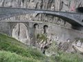
The climb to the Gotthardpass from Andermatt has a length of about 12km and reaches a height of 2106m. The heighdiference with the start is more than 600m. The average slope is 7,1%, with a maximum of 9%.
Naviga nel percorso in...
![]() App RouteYou Aprire
App RouteYou Aprire
![]()
Attendi, la tua stampa è in preparazione.
La tua stampa è pronta per il download. Buon divertimento in viaggio!
Elaborazione della richiesta non è riuscita. Si prega di riprovare.
<iframe src="https://plugin.routeyou.com/routeviewer/free/?language=it&params.route.id=1341709&params.language=en" width="100%" height="600" frameborder="0" allowfullscreen></iframe>
<a href="https://www.routeyou.com/en-ch/route/view/1341709/road-bike-route/climb-to-the-gotthardpass-from-andermatt?utm_source=embed&utm_medium=article&utm_campaign=routeshare" title="Climb to the Gotthardpass from Andermatt - RouteYou" target="_blank"><img src="https://image.routeyou.com/embed/route/960x670/1341709-en@2x.png" width="960" height="670" alt="Climb to the Gotthardpass from Andermatt"></a>
Altri commenti:
Prova questa funzionalità gratuitamente con un abbonamento di prova RouteYou Plus.
Se hai già un tale account, accedi ora.
Prova questa funzionalità gratuitamente con un abbonamento di prova RouteYou Premium.
Se hai già un tale account, accedi ora.
© 2006-2024 RouteYou - www.routeyou.com