3150 visite | Pubblica | Olandese
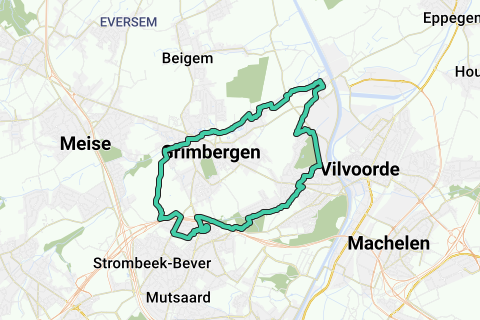
This walking/trail/cycling loop runs in a counterclockwise direction along the 2 most important streams around Grimbergen centurm: the Maelbeek (ventral and northern) and the Tangebeek (southern, sometimes called the 'Leibeek' in the past (Ferraris 1777). Both streams have great historical importance. De Maalbeel because of its many watermills (currently still the most densely populated watermill site in Flanders with working mills); the Tangebeek because of its historical importance as water protection of the Motte in the Borgt, where the first Berthouts lived.
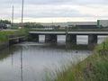
The historical and recreation interesting loop starts and stops at the sports hall Burnt Bridge (plenty of parking). You can of course start wherever the loop passes (e.g. Tommenmolen, Liermonen Alexius sub-stitch under Noodring, Borgt center, ...).
This loop is kept limited because of the distance:
1. There is no going to the source of the Maalbeel, which is far beyond Grimbergen. You can see her source here: https://www.routeyou.com/nl/location/view/47532480/bron-van-de-maalbeek.nl
To get to it, it is better suited:
https://www.routeyou.com/nl/route/view/530266/recreatieve-fietsroute/fietslus-15-watermolens-op-de-3-molenbeken-en-de-maalbeek-vertrek-s-gravenmolen-grimbergen-90km.nl (At the Maelbeek source you can shorten them to the more northern Molenbeek to return via Meise (Amelgemse Molenbeek).
2. Between the 's Gravenmolen on the Maalbeek, the distance is shortened to the source of the Tangebeek (which is therefore taken - near Haneveld, Bergmansbeekkweg old tram line Strombeek Het Voor, at the large pond ).
From the 's Gravenmolen -Spiegelhof- the road runs over a field path (with reasonable wart rubble waste) always in an upward line to its highest point Sint-Alexiuskliniek -last part is asphalt-. This is a tough climb of about 40 altimeters.
3. Due to the crossing of the Tangebeek under the Noordring, it cannot be followed in the bed, but a pleasant and fun path is followed that crosses the Tangebeek, and crosses it again via the Tangebeek forest and follows it further alongside.
4. The mouth of the Tangebeek and the Maelbeek is originally located in the turning dock east of the Zeekanaal. We follow both streams on the west of this Canal for as long as possible, but do not cross them along the Burnt Bridge around the 'current mouth of the Tangebeek (underground on the) or the Maelbeek (under the Danzas complex and Zenstsesteenweg, along the Daalstraat to the purified discharge of grimbergen's sewage at the end of the Daalstraat, in the Dorent-Nelebroek area where the Cargovil industrial zone has also manifested itself.
When ne Tangebeek is abandoned - old Humbeeksesteenwe just rebuilt for the slow road user - we go through the highest birth forest of Grimbergen, from where you have a beautiful view of the east. via exit along the oriolelaan the Nieuwe Schapenweg is taken towards the starting point
A very nice and pleasant walking / walking / cycling loop along both streams, measured at different locations for a nap and a drogje.
Not everything is paved because of the charm of having a low-traffic and quiet loop. So, in severe weather, it can be filthy in those places.
Have fun at this 2 brook walking loop!
Naviga nel percorso in...
![]() App RouteYou Aprire
App RouteYou Aprire
Vuoi smettere di vedere questo annuncio?
→ Upgrade ora
![]()
Attendi, la navigazione è in preparazione.
Ora puoi navigare. Buon divertimento in viaggio!
Elaborazione della richiesta non è riuscita. Si prega di riprovare.
Vuoi smettere di vedere questo annuncio?
→ Upgrade ora
![]()
Attendi, il tuo download è in preparazione.
Il tuo download è pronto. Buon divertimento in viaggio!
Elaborazione della richiesta non è riuscita. Si prega di riprovare.
Vuoi smettere di vedere questo annuncio?
→ Upgrade ora
![]()
Attendi, la tua stampa è in preparazione.
La tua stampa è pronta per il download. Buon divertimento in viaggio!
Elaborazione della richiesta non è riuscita. Si prega di riprovare.
<iframe src="https://plugin.routeyou.com/routeviewer/free/?language=it&params.route.id=2081876&params.language=en" width="100%" height="600" frameborder="0" allowfullscreen></iframe>
<a href="https://www.routeyou.com/en-be/route/view/2081876/walking-route/maelbeek-tangebeek-loop-grimbergen-16-1km-10mi?utm_source=embed&utm_medium=article&utm_campaign=routeshare" title="Maelbeek-Tangebeek loop Grimbergen (16,1km; 10Mi) - RouteYou" target="_blank"><img src="https://image.routeyou.com/embed/route/960x670/2081876-en@2x.png" width="960" height="670" alt="Maelbeek-Tangebeek loop Grimbergen (16,1km; 10Mi)"></a>
Altri commenti:
Prova questa funzionalità gratuitamente con un abbonamento di prova RouteYou Plus.
Se hai già un tale account, accedi ora.
Prova questa funzionalità gratuitamente con un abbonamento di prova RouteYou Premium.
Se hai già un tale account, accedi ora.
© 2006-2024 RouteYou - www.routeyou.com