A little south-east of the Saint-Mard settlement area flows the Ruisseau de Bruzeles, a ditch, from the wooded heights to the Vire. Along its course are three large stones on which Stone Age man sharpened his weapons and flint tools. These stones are called polishers, Fairy Stones or Witches' Pebbles.
The landscape full of relief of Saint-Mard therefore deserves to be qualified as prehistoric.
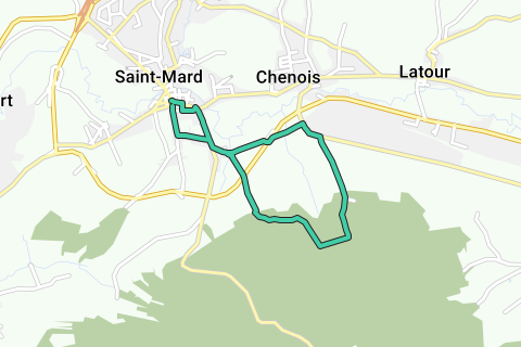
DISTANCE
About 6.5 km.
TYPE OF ROAD
Exclusively paved roads, except during the wooded part of the route, where you follow paths with base surface and occasionally sections of dirt forest road. The climb from Saint-Mard to the wood, the Bois de Côte, is very steep and offers no protection from the sun, at least not before noon. Even in rainy weather you don't really need rubber boots. Due to the steep slopes and the location of forest roads, it is impossible to take strollers or wheelchairs.
MARKUP
There is no real markup. Street names can be helpful.
PARKING
The city center of Saint-Mard is dominated by the church of Saint-Martin: large but actually not very pretty. You will find a large parking lot for several dozen cars on the right, along the facade. In front of the church stretches a traying square lined with chestnut trees, provided with a bandstand and several pews. You can also park along the square.
TOPOGRAPHIC MAP
IGN 71/5-6.
INFORMATION
Maison du Tourisme du Pays de Gaume, Rue des Grasses Oies 2b, 6760 Virton
Tel. 063 57 89 04
Fax 063 57 71 14
E-mail: mtg@soleildegaume.com
Internet: www.soleildegaume.com.
Naviga nel percorso in...
![]() App RouteYou Aprire
App RouteYou Aprire
Vuoi smettere di vedere questo annuncio?
→ Upgrade ora
![]()
Attendi, la navigazione è in preparazione.
Ora puoi navigare. Buon divertimento in viaggio!
Elaborazione della richiesta non è riuscita. Si prega di riprovare.
Vuoi smettere di vedere questo annuncio?
→ Upgrade ora
![]()
Attendi, il tuo download è in preparazione.
Il tuo download è pronto. Buon divertimento in viaggio!
Elaborazione della richiesta non è riuscita. Si prega di riprovare.
Vuoi smettere di vedere questo annuncio?
→ Upgrade ora
![]()
Attendi, la tua stampa è in preparazione.
La tua stampa è pronta per il download. Buon divertimento in viaggio!
Elaborazione della richiesta non è riuscita. Si prega di riprovare.
<iframe src="https://plugin.routeyou.com/routeviewer/free/?language=it&params.route.id=1186&params.language=en" width="100%" height="600" frameborder="0" allowfullscreen></iframe>
<a href="https://www.routeyou.com/en-be/route/view/1186/walking-route/saint-mard?utm_source=embed&utm_medium=article&utm_campaign=routeshare" title="Saint-Mard - RouteYou" target="_blank"><img src="https://image.routeyou.com/embed/route/960x670/1186-en@2x.png" width="960" height="670" alt="Saint-Mard"></a>
Altri commenti:
Prova questa funzionalità gratuitamente con un abbonamento di prova RouteYou Plus.
Se hai già un tale account, accedi ora.
Prova questa funzionalità gratuitamente con un abbonamento di prova RouteYou Premium.
Se hai già un tale account, accedi ora.
© 2006-2024 RouteYou - www.routeyou.com