Overview:
In this guide we take you to the summit of "Le Toûno", with a height of 3017m a high mountain which you will conquer.
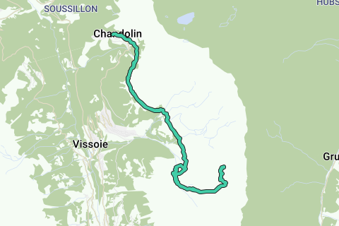
The starting of this hike is at Chandolin, parking spots are in the center of the village. When you enter it, just before the tourist center turn right and park your car on the parking lot. The parking is not free, so please fill the meter.
If you rather do not want to start from Chandolin, a possible secondary starting point is at Saint-Luc where you can take the Funiculair to Tignousa. The Funiculaire is some kind of ski lift witch takes you directly to Tignousa.
From Chandolin we head into the direction of Tignousa along "Chemin difficile", a coal term for the path to Tignousa witch stands for difficult path. Not that it is difficult: small debris field and rocks to climb over but all are in good state and can be easily be passed.
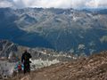
Once you made it to Tignousa you already can see the Toûno mountain and from that point it doesn't look easy to climb, let's say unclimable.
Just above Tignousa lies the astronomical observatory, defiantly worth a visit. Check the dates and times on their website.
We keep following in the direction of "Le Toûno", just before Hotel Weisshorn we walk into "Tsa du Toûno", a deserted small valley on it's own and a paradise to walk through. Not much hikers pass through here so you can enjoy pure nature. From here we get to the backside of the Toûno mountain and finally you'll see that you can conquer this mountain. The climb itself is a bit steep but with the view you'll get on the summit, it's sure worth it. A bench awaits you there so you can relax immediately.
To return back to Chandolin we almost take the exact route back but we do a neat little sidewalk. Just before you reach the "Torrent des Moulins" we turn right so that we follow this small river and keep it on our left side. This side path is a really nice place.
With all those kilometers in your feet, you can make a stop at the Tignousa station before you set foot to Chandolin.
Tips:
Hiking classification: T2 - Mountain hikes
Vertical ascent: 1273m
Vertical descent: 1290m
Long hike and bigger height difference, do take your time! The climb to the Toûno is a bit steep. All other paths clearly visible and easy with no particular difficulties. Try to reach the summit at noon and eat then.
Story:
This mountain was on my to-do list for quite a while and today it was finally the moment. Normaly the depart is from Saint-Luc where you would take the Funiculaire lift to Tignousa, but as i prefer to hike and always ignore lifts the starting point lies again in Chandolin.
The first part of the hike is very easy and after 4 years visiting the valley a bit boring. This because of the big path that runs from Tignousa to Hotel Weisshorn. But besides that, nice views and there is also a planetary path. When hiking in the direction of Hotel Weisshorn you already see the Toûno mountain and from that point of view you'll probably think this mountain can not be climbed without further equipment. To conquer the Toûno mountain we have to walk behind it. So just before Hotel Weisshorn it gets very interesting when we head to "Tsa du Toûno", a very desolated place and really nice to walk here.
It was a very cloudy start of the day and the summit of the Toûno mountain was in the clouds. So when we started the climb we knew we would end up in the clouds and so it was. But beside the clouds, it was also freezing cold. The freezing level laid on 2600m.
When we decided to return to Chandolin the clouds broke open and we finally had a view. And what a view it was, really beautiful. Normally it's the same route back to Chandolin but we took a little side path to a very neat little place what was really worth it.
Long hike but sure worth it.
Naviga nel percorso in...
![]() App RouteYou Aprire
App RouteYou Aprire
Vuoi smettere di vedere questo annuncio?
→ Upgrade ora
![]()
Attendi, la navigazione è in preparazione.
Ora puoi navigare. Buon divertimento in viaggio!
Elaborazione della richiesta non è riuscita. Si prega di riprovare.
Vuoi smettere di vedere questo annuncio?
→ Upgrade ora
![]()
Attendi, il tuo download è in preparazione.
Il tuo download è pronto. Buon divertimento in viaggio!
Elaborazione della richiesta non è riuscita. Si prega di riprovare.
Vuoi smettere di vedere questo annuncio?
→ Upgrade ora
![]()
Attendi, la tua stampa è in preparazione.
La tua stampa è pronta per il download. Buon divertimento in viaggio!
Elaborazione della richiesta non è riuscita. Si prega di riprovare.
<iframe src="https://plugin.routeyou.com/routeviewer/free/?language=it&params.route.id=2260165&params.language=en" width="100%" height="600" frameborder="0" allowfullscreen></iframe>
<a href="https://www.routeyou.com/en-ch/route/view/2260165/hiking-route/le-touno-3017m?utm_source=embed&utm_medium=article&utm_campaign=routeshare" title="Le Toûno (3017m) - RouteYou" target="_blank"><img src="https://image.routeyou.com/embed/route/960x670/2260165-en@2x.png" width="960" height="670" alt="Le Toûno (3017m)"></a>
Altri commenti:
Prova questa funzionalità gratuitamente con un abbonamento di prova RouteYou Plus.
Se hai già un tale account, accedi ora.
Prova questa funzionalità gratuitamente con un abbonamento di prova RouteYou Premium.
Se hai già un tale account, accedi ora.
© 2006-2024 RouteYou - www.routeyou.com