830 visite | Pubblica | Olandese
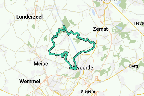
If you want a traffic-free trip of just over 32km (20Mi) along the rural roads (Humbeek, Zeekanaalzone, Verbrande Brug, Borcht, Veldkant, Beigem) in Grimbergen and you also want to address some special locations, then you are in the right place!
The loop is worked out in clockwork style along low-traffic/traffic-free roads and is largely on unpaved road and for a smaller part on asphalt/concrete roads; But all are really low-traffic. The entire route is perfect for the hiker and runner, and because the unpaved roads are well maintained and well maintained, it is also very doable for the recreational cyclist (who does not want to grind down 25 km / h): This loop is therefore a dive in 'Rural Grimbergen', with several stops for a drink.
90% of the loop passes through Grimberg's territory. A small part is provided along Eppegem to admire the Grimbergse Kattemeuterbos (border with Zemst) and the Dorent nature reserve on the Burnt Bridge. Rural roads/paths have also been used, so that the Schranshoeve in Eppegem has automatically been put on the menu.
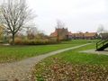
Departure and arrival of this drawn loop is situated at the playground of the Schranshoeve in Eppegem (Kreupelstraat). You can of course start this loop anywhere.
Various special locations and nature reserves are on the menu, and it has been ensured that these are addressed via many special paths / roads with a history.
The Schranshoeve takes you via an old tenant farm to the Dorent nature reserve that runs through to the Burnt Bridge.
Past the Burnt Bridge, the low-traffic road is taken but the old Humbeeksesteenweg (now only accessible to the slow road user), along the nature reserve Ter Tommen towards Borght. Because the Borght with her Motte has one of the oldest traces of Grimbergen, a detour is made along this Motte. Franks, Romans and the Berthouts had their fortress between the Senne and the Tangebeek (http://nl.wikipedia.org/wiki/Borgt).
Via the Borghtvoetweg (one of the oldest footpaths that connected the Borght with the higher country) the old 'Grimbergsesteenweg' is briefly taken, to descend back along the Tangebeek and two ponds near the TerTommen nature reserve.
From here it goes uphill to the 'Kattebergen', a crossroads of deeply cut hollow roads, and follow the 'Nieuwe Schapenweg'. A little further on, the Hertogenvoetweg field path is taken with a beautiful view of the Basilica on its left, and the Burnt and Humbeek bridge on its right horizon.
Just over the Veldkantstraat (pay attention!) we dive into the Diegemput and go in a counterclockwise way through the newly constructed park domain Lintbos (formerly a training center for pilots of Sabena, later a small airport for recreational aviators, currently a park zone with extensive trees with views to the horizon - reminiscent of the runways-. Leave this vast domain along its most southwestern exit, after which the edge of this domain is followed to the Grote Heirbaan.
Here we also come across a strange large concrete circle in which the 360° are divided into pieces of 10°: see the different POIs when entering the Lintbos. http://www.aviationpros.com/article/10385554/aircraft-compass-swing tells you more about it: it is a calibration device for aircraft:
This was placed by the Germans in 1941 to calibrate/calibrate their aircraft so that the orientation of their flight could be found by comparing it with the magnetic north. Therefore, this disk was placed in such a way that the 0° corresponds to magnetic north, not geographical north.
See also other aircraft calibration sections here: https://www.google.be/search?q=Compass+Swing&biw=1280&bih=904&tbm=isch&tbo=u&source=univ&sa=X&ei=QvRIVIPjPKe2ygPCtoKYBg&ved=0CCgQsAQ
You can find more about the history of this calibration disc at Grimbergen Airport here: http://www.luchtvaarterfgoed.be/content/kalibreerschijf-0
From there we dive through a large bend through the fields of Beigem. At the border with Humbeek (Coppendries) the footpaths are once again used to get past the fields at the Gravenbos in Humbeek. There the castle domain De Eiken, the Forest Chapel and the cave of Our Lady (Lourdes Grotto) are passed. (The very last part of this forest, on the Zeekanaal, can be quite soggy.)
The Humbeek bridge is taken at the Zeekanaal, where a number of field and foot roads along the Kattemeuterbos return to the Schranshoeve.
Summary:
Via low-traffic / unpaved (but easily cycleable) historic field roads / paths through the open fields you will pass the following nature reserves:
Dorent; Ter Tommen; Lintbos (with a historically unique calibration disc); 's Gravenbos; Kattemeuterbos.
At the same time, a number of historical or religious sites are addressed:
Schranshoeve; several old tenant courts; Motte in the Borcht; (Tommenmolen); Castle De Eiken; Forest chapel; Lourdes Grotto.
Naviga nel percorso in...
![]() App RouteYou Aprire
App RouteYou Aprire
Vuoi smettere di vedere questo annuncio?
→ Upgrade ora
![]()
Attendi, la navigazione è in preparazione.
Ora puoi navigare. Buon divertimento in viaggio!
Elaborazione della richiesta non è riuscita. Si prega di riprovare.
Vuoi smettere di vedere questo annuncio?
→ Upgrade ora
![]()
Attendi, il tuo download è in preparazione.
Il tuo download è pronto. Buon divertimento in viaggio!
Elaborazione della richiesta non è riuscita. Si prega di riprovare.
Vuoi smettere di vedere questo annuncio?
→ Upgrade ora
![]()
Attendi, la tua stampa è in preparazione.
La tua stampa è pronta per il download. Buon divertimento in viaggio!
Elaborazione della richiesta non è riuscita. Si prega di riprovare.
<iframe src="https://plugin.routeyou.com/routeviewer/free/?language=it&params.route.id=757102&params.language=en" width="100%" height="600" frameborder="0" allowfullscreen></iframe>
<a href="https://www.routeyou.com/en-be/route/view/757102/jogging-route/grimberg-20mi-32-2km-20mi?utm_source=embed&utm_medium=article&utm_campaign=routeshare" title="Grimberg 20Mi (32,2km; 20Mi) - RouteYou" target="_blank"><img src="https://image.routeyou.com/embed/route/960x670/757102-en@2x.png" width="960" height="670" alt="Grimberg 20Mi (32,2km; 20Mi)"></a>
Altri commenti:
Prova questa funzionalità gratuitamente con un abbonamento di prova RouteYou Plus.
Se hai già un tale account, accedi ora.
Prova questa funzionalità gratuitamente con un abbonamento di prova RouteYou Premium.
Se hai già un tale account, accedi ora.
© 2006-2024 RouteYou - www.routeyou.com