Source: Wizpr.guide
Droits d'auteur: All rights reserved
1683 vues | Publique | Néerlandais
You would not easily associate Zelzate with greenery and yet you will find beautiful pieces of nature, such as the cross-border nature reserve Canisvliet, which is now 100 hectares in size. You will find several creeks, wet grasslands, young forest and an old orchard. It is wonderful to walk in this home port for water birds and special plants. In several places there are lookouts for bird watching. On the website of visitor center De Baeckermat in the Dutch Westdorpe you can read seasonal reports of the ins and outs of this nature reserve.
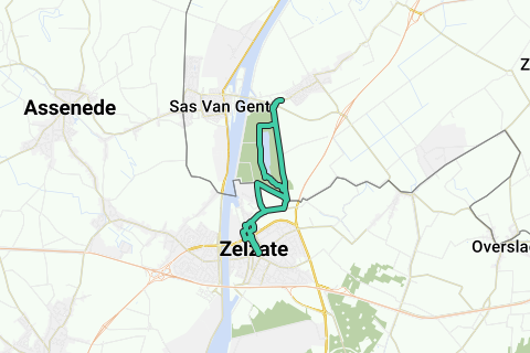
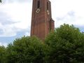
1. Start this walk along unexpected green spots towards the Netherlands on the Grote Markt (V) of Zelzate. You have a wide range of parking spaces, restaurants and shops. Keep the Sint-Laurentiuskerk (1950) on the right and start towards the main road. At the traffic lights, cross Kanaalstraat/R4 and continue straight on Havenlaan. After café 't Withof you turn right. Bend in this Peperstraat to the left, into the Kerkstraat. At the intersection, turn right at the cemetery into Sint-Stevenstraat. At the end of this residential area turn left. This way you quickly end up in the green, in a spur of the Meetjesland creek area. Just past the Grenshoeve you reach a quadrangle, immediately the Belgian-Dutch border. You cross the Stekkerweg, straight ahead into the straight drive. According to the signpost, this Fishermen's Shortening takes you 4 km further in Westdorpe, part of Terneuzen and the second longest ribbon village in the Netherlands. On the way there, just past the fisherman's house (1), take the wonderful walking path around the Canisvlietse Creek (2) on the left. According to the information board about the Canisvliet nature reserve, only intended for hikers, although you can encounter cyclists. Quietly follow the bank of the Canisvliet creek, with jetties that serve as swimming paddles on hot days or give anglers a cutting. Trees and shrubs provide shade, while waterfowl fly up in terror. The walking path occasionally turns away from the water, to the open field, with the industry of Sas van Gent in the décor. Halfway a road leads left to the Sint-Anthonykade along the Ghent-Terneuzen canal, opened in 1927 and now intended for ships up to 80,000 tons. Signs further on say that the Grenslandpad and the GR5A ring road East and West Flanders also run here.
2. At the end of the creek, bend to the right, over the stepping stones next to a fence. The path continues to the left and towards the bridge, again through a fence with stepping stones. Straight ahead is the Vissersverkorting, but better follow a wide grass path between the trees on the left, with a green pole head (right GR and red pole head). Almost back in civilization, the parallel path leads to the drive. Here you leave the Canisvliet nature reserve (42 ha in total, with several creeks) and cross the Oostpoortweg (left to the swing bridge towards Sas van Gent) and the roundabout via the cycle path (Zeeland network) and cross the roundabout to Westdorpe. Follow this Bernhardstraat to the visitor center De Baeckermat (3). Straight ahead it goes to Oud Westdorpe. In De Baeckermat (closed on Mondays) you can relax on the terrace or in the restaurant, or buy local products in the farm shop. Then return to the roundabout. On the way back you can follow this lane for local traffic or turn right a little further into a path to the creek and follow the other bank.
3. Past the Bekkerdreef on the left, the path from the right (sign Bird breeding and resting area) leads back to the drive. Past an agricultural lock and the fisherman's house, you now turn right on the asphalt road, towards Zelzate, past an information board (4) about the Nature Restoration of the Canisvliet creek and the Molenkreek. Just before a row of trees, turn left. This Karnemelkstraat takes you past a business zone, container park and water purification station back into the Sint-Stevenstraat. To the right and at the cemetery now straight ahead, into the narrow K. Waegenaarstraat. Back in the Havenlaan you can turn right to the protected toll office and the new marina. On the left it goes back to the Grand Place. Past the police station, turn right into another green lung, a park with a fishing pond. Over the parking lot to the left, back to the Grote Markt with the town hall and the statue of Mietje Stroel.
Parcourir l'itinéraire dans...
![]() Application RouteYou Ouvrez
Application RouteYou Ouvrez
Plus voir cette annonce?
→ Améliorez maintenant
![]()
Veuillez patienter, la navigation est en cours de préparation.
Vous pouvez maintenant naviguer. Amusez-vous en route!
Le traitement de votre requête a échoué. S'il vous plaît réessayez.
Plus voir cette annonce?
→ Améliorez maintenant
![]()
Veuillez patienter, votre téléchargement est en cours de préparation.
Votre téléchargement est prêt. Amusez-vous en route!
Le traitement de votre requête a échoué. S'il vous plaît réessayez.
Plus voir cette annonce?
→ Améliorez maintenant
![]()
Veuillez patienter, votre impression est en cours de préparation.
Votre impression est prête à être téléchargée. Amusez-vous en route!
Le traitement de votre requête a échoué. S'il vous plaît réessayez.
Plus voir cette annonce?
→ Améliorez maintenant
![]()
Veuillez patienter, votre téléchargement est en cours de préparation.
Votre téléchargement est prêt. Amusez-vous en route!
Le traitement de votre requête a échoué. S'il vous plaît réessayez.
<iframe src="https://plugin.routeyou.com/routeviewer/free/?language=fr&params.route.id=5346769&params.language=en" width="100%" height="600" frameborder="0" allowfullscreen></iframe>
<a href="https://www.routeyou.com/en-nl/route/view/5346769/recreational-walking-route/zelzaats-green?utm_source=embed&utm_medium=article&utm_campaign=routeshare" title="Zelzaats green - RouteYou" target="_blank"><img src="https://image.routeyou.com/embed/route/960x670/5346769-en@2x.png" width="960" height="670" alt="Zelzaats green"></a>
Commentaires supplémentaires:
Essayez cette fonctionnalité gratuitement avec un abonnement d'essai RouteYou Plus.
Si vous avez déjà un tel compte, connectez-vous maintenant.
Essayez cette fonctionnalité gratuitement avec un abonnement d'essai RouteYou Premium.
© 2006-2024 RouteYou - www.routeyou.com