3920 visitas | Pública | Alemán • Francés • Neerlandés
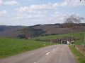
The north of Luxembourg (also called Ösling) is ideal for cycling: the rivers Clerve (german: Clierf), Sauer (French: Sauer), Wiltz and Our have carved deep valleys into the plateau. The resulting slopes are heavily wooded. On the plateaus, on the other hand, agriculture is practiced, so that you have a clear view at the top on most climbs.
The roads in Luxembourg are also of excellent quality. And Luxembourg has several cycle paths: paved cycle paths, often free of charge. This route follows the Van de Clerve cycle path (PC21), a completely autonomous paved cycle path in the valley of the winding river Clerve.
The start of the route is in Dasburg-Pont, on the border between Luxembourg and Germany. You follow the trail clockwise and then drive to Germany first. First, you will have two ascents in Germany before diving in Luxembourg.
You get the following climbs for the bikes along the entire route:
- Kapellenberg (D) of Dasbourg-Pont (L), length 3.7 km, difference in altitude 195 m, difference in altitude 5.3% (max: 12%)
- Rodershausen (D) de Gemünd (D), length 4.2 km, 260 metres in altitude, average. 6.2 % (max. 12 %)
- Gralinger Coast, length 2.2 km, difference in altitude 158 m, average increase of 7%
- Rämesbierg de Boukelzermillen, length 4.5 km, difference in altitude 245 m, average. Increase of 5.4 % (max.: 10 %)
- Konerhaff coast from Kautenbach, length 3.0 km, 185 m altitude, average. Increase of 6.2% (max. 11%)
- Bockholtz coast from Pintsch, length 4.7 km, 185 m altitude, average. 3.9 % (max. 7 %)
There are many variations to master on this route: There are countless climbs around Kautenbach and the Our Valley.
Since this route runs on very quiet roads (with the exception of the N10 in the Urdal, which can be a bit busier) and avoids the large squares, it is only possible to eat something in a few villages (such as Kautenbach).
Navegar ruta en...
![]() Aplicación RouteYou Abre
Aplicación RouteYou Abre
![]()
Espere, se está preparando su impresión.
Su impresión está lista para descargarse. ¡Diviértete en el camino!
El procesamiento de la solicitud ha fracasado. Por favor, inténtelo de nuevo.
![]()
Espere, se está preparando su descarga.
Su descarga esta lista. ¡Diviértete en el camino!
El procesamiento de la solicitud ha fracasado. Por favor, inténtelo de nuevo.
<iframe src="https://plugin.routeyou.com/routeviewer/free/?language=es&params.route.id=5016752&params.language=en" width="100%" height="600" frameborder="0" allowfullscreen></iframe>
<a href="https://www.routeyou.com/en-lu/route/view/5016752/road-bike-route/via-ferrata-north-of-luxembourg-between-sauer-wiltz-clerve-and-ourdal?utm_source=embed&utm_medium=article&utm_campaign=routeshare" title="Via ferrata north of Luxembourg between Sauer, Wiltz, Clerve and Ourdal - RouteYou" target="_blank"><img src="https://image.routeyou.com/embed/route/960x670/5016752-en@2x.png" width="960" height="670" alt="Via ferrata north of Luxembourg between Sauer, Wiltz, Clerve and Ourdal"></a>
Comentarios adicionales:
Pruebe esta funcionalidad gratis con una suscripción de prueba RouteYou Plus.
Si ya dispone de dicha cuenta, conectarse ahora.
Pruebe esta funcionalidad gratis con una suscripción de prueba RouteYou Premium.
© 2006-2024 RouteYou - www.routeyou.com