1373 visitas | Pública | Francés • Neerlandés
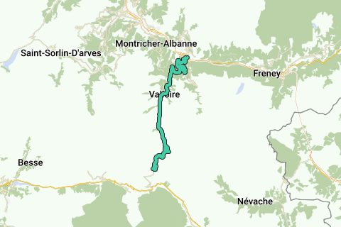
Climb to the Col de Galibier from Saint Michel de Maurienne, via Col de Télégraphe. The climb gets you to a height of 2642m over a length of about 35 km. The height difference from the start is 1933m. The average slope is 5.48% with max. slopes of 15%. The col is open from June till October.
Navegar ruta en...
![]() Aplicación RouteYou Abre
Aplicación RouteYou Abre
![]()
Espere, se está preparando su impresión.
Su impresión está lista para descargarse. ¡Diviértete en el camino!
El procesamiento de la solicitud ha fracasado. Por favor, inténtelo de nuevo.
<iframe src="https://plugin.routeyou.com/routeviewer/free/?language=es&params.route.id=2005972&params.language=en" width="100%" height="600" frameborder="0" allowfullscreen></iframe>
<a href="https://www.routeyou.com/en-fr/route/view/2005972/road-bike-route/col-du-galibier-from-st-michel-de-mairienne?utm_source=embed&utm_medium=article&utm_campaign=routeshare" title="Col du Galibier from St.Michel de Mairienne - RouteYou" target="_blank"><img src="https://image.routeyou.com/embed/route/960x670/2005972-en@2x.png" width="960" height="670" alt="Col du Galibier from St.Michel de Mairienne"></a>
Comentarios adicionales:
Pruebe esta funcionalidad gratis con una suscripción de prueba RouteYou Plus.
Si ya dispone de dicha cuenta, conectarse ahora.
Pruebe esta funcionalidad gratis con una suscripción de prueba RouteYou Premium.
Si ya dispone de dicha cuenta, conectarse ahora.
© 2006-2024 RouteYou - www.routeyou.com