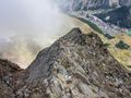
This hike takes you to the eagles nest high in the mountains to the Mischabelhütte which is situated on the eastern ridge of the Lenzspitze. During the whole climb towards to mountain cabin, a tremendous view awaits.
!!!WARNING!!! T4 Alpine hike !!!WARNING!!!
This hike takes you very high up the mountains, from a height of 2800m a "via ferrata"/"Klettersteig" section starts along the ridge of the Distelhorn up onto the mountain cabin. The roads are clearly marked and sections are secured with ropes and iron so you don't need extra equipment. The climb is very steep with sections of more than 45°. You must be sure footed and totally not afraid of heights (you'll see the steep and deep abyss always near you).
Don't try this hike when you don't have mountain experience or when weather conditions aren't good. Due to the height of the cabin, snowfields are possible making it more difficult.
This hike is very demanding and takes much time due to the difficult terrain. Climbing up goes slowly and even returning back to Saas-Fee is very time consuming. Leave early when you do this hike in one day, or make a reservation in the mountain cabin to sleep over and return the day after.
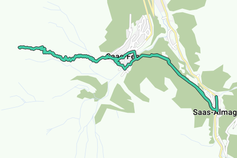
This route starts in Saas-Almagell but can also be started from Saas-Fee. This would make the hike 8km shorter. This means that you'll conquer the 1600m height difference in less than 4km distance so you'll know it's going to be tough.
Navegar ruta en...
![]() Aplicación RouteYou Abre
Aplicación RouteYou Abre
¿No quieres ver más este anuncio?
→ Mejorar ahora
![]()
Espere, se está preparando la navegación.
Ahora puede navegar. ¡Diviértete en el camino!
El procesamiento de la solicitud ha fracasado. Por favor, inténtelo de nuevo.
¿No quieres ver más este anuncio?
→ Mejorar ahora
![]()
Espere, se está preparando su descarga.
Su descarga esta lista. ¡Diviértete en el camino!
El procesamiento de la solicitud ha fracasado. Por favor, inténtelo de nuevo.
¿No quieres ver más este anuncio?
→ Mejorar ahora
![]()
Espere, se está preparando su impresión.
Su impresión está lista para descargarse. ¡Diviértete en el camino!
El procesamiento de la solicitud ha fracasado. Por favor, inténtelo de nuevo.
¿No quieres ver más este anuncio?
→ Mejorar ahora
![]()
Espere, se está preparando su descarga.
Su descarga esta lista. ¡Diviértete en el camino!
El procesamiento de la solicitud ha fracasado. Por favor, inténtelo de nuevo.
<iframe src="https://plugin.routeyou.com/routeviewer/free/?language=es&params.route.id=4153034&params.language=en" width="100%" height="600" frameborder="0" allowfullscreen></iframe>
<a href="https://www.routeyou.com/en-ch/route/view/4153034/hiking-route/mischabelhutte-3340m?utm_source=embed&utm_medium=article&utm_campaign=routeshare" title="Mischabelhütte 3340m - RouteYou" target="_blank"><img src="https://image.routeyou.com/embed/route/960x670/4153034-en@2x.png" width="960" height="670" alt="Mischabelhütte 3340m"></a>
Comentarios adicionales:
Pruebe esta funcionalidad gratis con una suscripción de prueba RouteYou Plus.
Si ya dispone de dicha cuenta, conectarse ahora.
Pruebe esta funcionalidad gratis con una suscripción de prueba RouteYou Premium.
© 2006-2024 RouteYou - www.routeyou.com