An incredible panorama route which takes you to Europe's largest erosion site 'Illgraben' and spectacular views over the Rhone valley.
Route:
This route starts in the village of Chandolin, it's one of the highest villages of the Alps and is situated at 2000m above sea-level. Parking can be found above the tourist office in the center of the village.
From the tourisme Office we follow the main road to the old center of Chandolin and take the first road on the right. The road leads up and brings you at the border of the forest. Once arrived at a small parking lot under the trees, you leave the main road and go through the parking lot , at the end you'll find a small but very beautiful path into the forest.After 700 meters the path turns up the hill and back on a big gravel road where we go left.The road is very easy now with little difference in height and gives some nice views over the Rhone Valley.
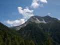
After 2km you'll see a small path on the right which brings you on the Illgraben erosion site; the view here is really amazing.
From the Illgraben you'll go back to the main road where we continue in the direction of Ponchet, along the way you'll get more splendid views over the Illgraben erosion site. At Ponchet you can rest out a bit.
To make the hike more adventurous we turn left at Ponchet in the direction of Soussillon, a very small village below Chandolin that's worth a visit. From Soussillon awaits a good climb back to Chandolin where you go through the old part of the village that's very authentic.
Route difficulty: T2 - Mountain hike
My experience:
First hike of my three weeks in Switzerland. The hike started in Chandolin where we were staying. From there headed to the Illgraben, a very large erosion site. Weather was great but very warm, it made the hike a bit more heavy. After the Illgraben we where heading to Ponchet where we still had some nice views over the Illgraben. At Ponchet it was time to go way down to the lower village of Soussillon before heading back to Chandolin. Not that there was much to see in Soussillon but we wanted to end with a climb. So from Soussillon we headed back to Chandolin, a nice climb to end this journey.
Statistics:
Length: 12.5 km
Duration: 3 hours, 18 minutes, 14 seconds
Vertical up: 798.3 m
Vertical down: 767.1 m
Average Speed: 3.8 km/h
Navegar ruta en...
![]() Aplicación RouteYou Abre
Aplicación RouteYou Abre
¿No quieres ver más este anuncio?
→ Mejorar ahora
![]()
Espere, se está preparando la navegación.
Ahora puede navegar. ¡Diviértete en el camino!
El procesamiento de la solicitud ha fracasado. Por favor, inténtelo de nuevo.
¿No quieres ver más este anuncio?
→ Mejorar ahora
![]()
Espere, se está preparando su descarga.
Su descarga esta lista. ¡Diviértete en el camino!
El procesamiento de la solicitud ha fracasado. Por favor, inténtelo de nuevo.
¿No quieres ver más este anuncio?
→ Mejorar ahora
![]()
Espere, se está preparando su impresión.
Su impresión está lista para descargarse. ¡Diviértete en el camino!
El procesamiento de la solicitud ha fracasado. Por favor, inténtelo de nuevo.
<iframe src="https://plugin.routeyou.com/routeviewer/free/?language=es&params.route.id=2260494&params.language=en" width="100%" height="600" frameborder="0" allowfullscreen></iframe>
<a href="https://www.routeyou.com/en-ch/route/view/2260494/hiking-route/to-the-illgraben-erosion-site-and-soussillon?utm_source=embed&utm_medium=article&utm_campaign=routeshare" title="To the Illgraben erosion site and Soussillon - RouteYou" target="_blank"><img src="https://image.routeyou.com/embed/route/960x670/2260494-en@2x.png" width="960" height="670" alt="To the Illgraben erosion site and Soussillon"></a>
Comentarios adicionales:
Pruebe esta funcionalidad gratis con una suscripción de prueba RouteYou Plus.
Si ya dispone de dicha cuenta, conectarse ahora.
Pruebe esta funcionalidad gratis con una suscripción de prueba RouteYou Premium.
Si ya dispone de dicha cuenta, conectarse ahora.
© 2006-2024 RouteYou - www.routeyou.com