2577 visitas | Pública | Neerlandés
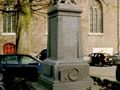
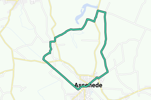
Appointment at the Sint-Petrus en Martinuskerk (V) in Assenede. The oldest parts of the church are Romanesque, the side choirs early Gothic and the tower dates from the 15th and 17th centuries. Opposite the church is the old town hall, a beautiful late classical building. Leave, with your back to the church, to the right, towards Zelzate. After 250 m, where the main road turns left, go diagonally right on the asphalt road, right next to house number 40B. The asphalt road immediately turns left and takes you 300 m further to a paved, straight cycle path. Walk via a bicycle and pedestrian axis to the right on the cycle path, direction Boekhoute. The polder landscape is wide and quiet. After almost 1,200 m at a first intersection and 300 m further at a second intersection, continue straight ahead. 200 m further, at the next intersection, walk to the right on a single-lane concrete road.
The landscape remains remarkably flat and open. At the fork, turn left and walk 300 m further right into the Kapellewegel. At the end of the Kapellewegel, step 30 m left onto the concrete and then to the left into the Kapellestraat. After 150 m, turn right into Doornendijkstraat (also sign Rode Geul route). 700 m further you come to a fork with an information board 1 about the Grote Geul and the creek area. In the early Middle Ages, this area still consisted of salt marshes and mudflats. From the fifteenth century onwards, reclamation began. The creeks are remnants of the gullies that were created by floods and dike breaches in the same century. After the restoration of the dikes at the end of the sixteenth century, most of the gullies gradually dried up. The largest, such as the Grote Geul on the right and the Red Trench a few hundred meters further on the left, remained as open puddles in the landscape. They are now a real paradise for many species of waterfowl. Walk between the two roads on a narrow path up and 20 m further through a gate into a nature reserve (also red and white GR sign). With a buggy you stay left under and along the dike. You now walk for almost a kilometer on top of the dike between beautiful rows of canada poplars, with a view of the Grote Geul on the right and a view of the green lakes on the left with the Red Trench behind it. After about 500 m you have the opportunity to go through a gate on the right under the dike to close to the water. Climb back on the dike, the path along the water does not lead anywhere. After almost a kilometer, again via a gate, leave the nature reserve and walk to the right down the dike and under the dike further to the right. The earth road becomes cobblestone road and takes you 250 m further to the Hollekenstraat. On the right there is an old café, where you can still go in the evening or on Sunday afternoon for a fresh pint. Walk to the left along the Hollekenstraat and after 150 m turn right down and further down and parallel to the Hollekenstraat. With a buggy you can possibly stay on top of the street. Continue for 250 m to the right into Oude Molenstraat. A little further you walk over the Vlietbeek and a little further right into the Smoutersdijkstraat. Furthermore, enjoy the wide views with here and there a farmer's activity. After almost 2 kilometers, continue straight into the Valkstraat. Bend another 500m to the right in the Groenendijkstraat, but stay right under the dike. At the end of the Groenendijkstraat turn right and a little further left via the Hoogstraat back to the church of Assenede. In the center there are some good mussel restaurants - Assenede is known as a mussel village - but of course you can also go there for another snack or drink.
Navegar ruta en...
![]() Aplicación RouteYou Abre
Aplicación RouteYou Abre
¿No quieres ver más este anuncio?
→ Mejorar ahora
![]()
Espere, se está preparando la navegación.
Ahora puede navegar. ¡Diviértete en el camino!
El procesamiento de la solicitud ha fracasado. Por favor, inténtelo de nuevo.
¿No quieres ver más este anuncio?
→ Mejorar ahora
![]()
Espere, se está preparando su descarga.
Su descarga esta lista. ¡Diviértete en el camino!
El procesamiento de la solicitud ha fracasado. Por favor, inténtelo de nuevo.
¿No quieres ver más este anuncio?
→ Mejorar ahora
![]()
Espere, se está preparando su impresión.
Su impresión está lista para descargarse. ¡Diviértete en el camino!
El procesamiento de la solicitud ha fracasado. Por favor, inténtelo de nuevo.
¿No quieres ver más este anuncio?
→ Mejorar ahora
![]()
Espere, se está preparando su descarga.
Su descarga esta lista. ¡Diviértete en el camino!
El procesamiento de la solicitud ha fracasado. Por favor, inténtelo de nuevo.
<iframe src="https://plugin.routeyou.com/routeviewer/free/?language=es&params.route.id=5294892&params.language=en" width="100%" height="600" frameborder="0" allowfullscreen></iframe>
<a href="https://www.routeyou.com/en-be/route/view/5294892/recreational-walking-route/along-polders-and-creeks-in-assenede?utm_source=embed&utm_medium=article&utm_campaign=routeshare" title="Along polders and creeks in Assenede - RouteYou" target="_blank"><img src="https://image.routeyou.com/embed/route/960x670/5294892-en@2x.png" width="960" height="670" alt="Along polders and creeks in Assenede"></a>
Comentarios adicionales:
Pruebe esta funcionalidad gratis con una suscripción de prueba RouteYou Plus.
Si ya dispone de dicha cuenta, conectarse ahora.
Pruebe esta funcionalidad gratis con una suscripción de prueba RouteYou Premium.
© 2006-2024 RouteYou - www.routeyou.com