8550 visitas | Pública | Neerlandés
Please note: due to the construction of the (now completed) Terhills holiday park, the cycle path between Terhillspark and As is not passable at Terhillspark. No detour route is indicated in the direction of As! Only coming from the direction of As is a detour indicated: it goes via an unpaved road (easily cycled by road bike) to the N75 (Boslaan), then via the Boslaan to the Nationaal Parklaan (see photo, or see: https://www.strava.com/activities/2783104466). In all likelihood, a new section of cycle path will be built to bypass the holiday park: it will be a floating foot/cycle path over a distance of about 350 metres. According to the latest reports, the Province of Limburg aims to have the pontoon cycle path ready in December 2023 (under the working title 'Cycling between Terhills').
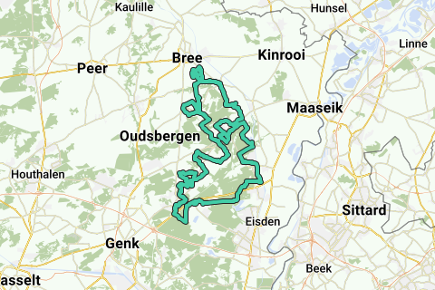
The Kempisch Plateau (or Kempens Plateau) is a plateau that rises 30 to 50 meters above the surrounding landscape. It stretches from Bree in the north, to Gellik in the south. The edges on the east side of this plateau are steep with height differences of 30 to 50 meters. On the plateau it is mainly the Bosbeek that has carved out some relief (up to 20 meters height difference). In the northern part, the Itterbeek and the Eetsevelderbeek have carved out some relief in the plateau.
The route starts in Opitter clockwise and descends in a southerly direction. Sometimes you follow busier lanes with bike lanes along them, but no longer than a mile. Around Opoeteren there are some climbs waiting, of which the Jonkersweg is the steepest (up to 10%). The biggest height difference can be found near Dilsen. Unfortunately, since 2017 it is no longer allowed for cyclists to cycle from Dilsen via the N771 and the Driepaal road, due to a new traffic situation around the new access road to the industrial area of Dilsen (Heulentakstraat). As a result, the ascent of the Driepaal is no longer possible. A new cycle path has been built to bridge this part, which leads to the tourist cycle path Maaseik - As. You descend this cycle path and then cycle a few times along the Zuid-Willemsvaart canal.
Just north of Maasmechelen Village, turn to the new gateway to the Hoge Kempen National Park (site of Connecterra and Cablepark Terhills) and cycle on new asphalted roads and cycle paths towards NIeuw-Homo. The cycle path between the entrance gate and Nieuw-Homo has been completed since the end of April 2018, with even a steep climb of up to 17%! The cycle path just past Nieuw-Homo through the former sand quarry towards As is already cycleable at the beginning of 2019 and so I have adjusted the route accordingly. You therefore no longer have to follow the busy N75 between Nieuw-Homo and As.
Then you cycle on free-lying cycle paths along the Mechelse Heide and cycle back towards As. From As you cross the upper reaches of the Bosbeek valley, with some short climbs on both sides of the valley. Especially the Caelenberg and the Bergstraat stand out in terms of steepness. Fortunately, the upper reaches of the Bosbeek is a nature reserve, so you can cycle the bosbeek valley on often quiet roads (sometimes car-free roads).
Via the Dornerheide and the forest area between Opoeteren and Neerglabbeek, you cycle (sometimes on free-lying asphalted cycle paths) towards the northern part of the Kempisch Plateau. There, especially the Steenberg will let you make an effort at the end before you reach Opitter again.
Navegar ruta en...
![]() Aplicación RouteYou Abre
Aplicación RouteYou Abre
![]()
Espere, se está preparando su impresión.
Su impresión está lista para descargarse. ¡Diviértete en el camino!
El procesamiento de la solicitud ha fracasado. Por favor, inténtelo de nuevo.
![]()
Espere, se está preparando su descarga.
Su descarga esta lista. ¡Diviértete en el camino!
El procesamiento de la solicitud ha fracasado. Por favor, inténtelo de nuevo.
<iframe src="https://plugin.routeyou.com/routeviewer/free/?language=es&params.route.id=5281110&params.language=en" width="100%" height="600" frameborder="0" allowfullscreen></iframe>
<a href="https://www.routeyou.com/en-be/route/view/5281110/road-bike-route/variant-kempisch-plateau-climbing-route?utm_source=embed&utm_medium=article&utm_campaign=routeshare" title="Variant Kempisch Plateau climbing route - RouteYou" target="_blank"><img src="https://image.routeyou.com/embed/route/960x670/5281110-en@2x.png" width="960" height="670" alt="Variant Kempisch Plateau climbing route"></a>
Comentarios adicionales:
Pruebe esta funcionalidad gratis con una suscripción de prueba RouteYou Plus.
Si ya dispone de dicha cuenta, conectarse ahora.
Pruebe esta funcionalidad gratis con una suscripción de prueba RouteYou Premium.
© 2006-2024 RouteYou - www.routeyou.com