234 Aufrufe | Öffentlich
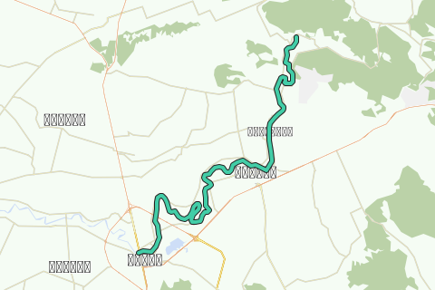
This kayak track is the second track of the Lower Pa Sak River and is part of the Pa Sak River Project set up by Ayutthaya kayaking Experience [AKE] aiming to make the necessary pre-arrangements in order to execute a 15-day long kayak trip from the source of the Pa Sak River high in the Phetchabun Mountain Range in Loei Province until its confluence with the Lopburi River, northeast of Ayutthaya and before it runs into the Chao Phraya River in the southeast of the city near Wat Phanang Choeng (Thailand).
The Pa Sak River, translated the "Teak Forest River", a major tributary of the Chao Phraya River, draining borderlands on the eastside of the Central Plain, finds its source in the highlands of Phetchabun Province and flows for hundreds of kilometers through the central plains of the Lopburi and Saraburi provinces, to join the Chao Phraya River at Ayutthaya.
The river descends from the mountainous north in Dan Sai District of Loei Province (1,746 m) to the south reaching its lowest point (3 m) in Uthai District of Ayutthaya Province. Short tributaries from the east and the west, join the river on its course to the Chao Phraya. Tributaries of the Pa Sak include: Lam Muak Lek (Muak Lek) , Huai Nam Phung (Ban Hin Hao), Huai Pa Daeng (Ban Pa Daeng), Lam Kong (Ban Wang Tha Di), Lam Sonthi (Ban Tha Yiam & Ban Na Som), Huai Wang Chomphu (Ban Wang Chomphu), Huai Na (Ban Huai Na), Huai Nam Chun (Ban Fai Wang Bon), Huai Nam Duk (Ban Pak Chong), Huai Khon Kaen (Ban Wang Khon Du), Huai Yai (Ban Sakae Ngam), Huai Saduang Yai (Ban Thai Bun), Khlong Ban Bong (Ban Chaliang Lap), Huai Yai (Ban Huai Yai Nua), Huai Tarang (Ban Huai Yai Nua), Huai Yai (Ban Hin Dat), Huai Lam Narai (Ban Lam Narai), Lam Kot Thong (Ban Lam Kot Thong) and Lam Phaya Klang (Ban Pang Hu Sua). Main cities along the Pa Sak River are Phetchabun, Saraburi and Ayutthaya.
The Pasak River includes both the central alluvial plain and North-east plateau and is divided into nine sub-basins. The river basin contains both urban and agricultural areas with the water resource being utilized mainly for paddy irrigation.
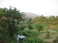
This track brings you into the lower central plains of Saraburi. The tour will take 6-7 hours according to your level of physical fitness, the conditions of the water current, and your personal kayaking experience. Highlights are listed to give you a number of reference points on this tour itinerary. Don not initiate this tour without the necessary physical fitness and preparation.
The Pa Sak River leaves the foothills on the western limits of the Sankamphaeng Range and flows south towards the city of Saraburi. After leaving the hills, we find the first fish farms near Ban Pa. Going south, unfortunately a pea-green substance colours the river; likely algal blooms as a result of an excessive use of nutrients and fish waste by the farmers.
The current is slowing down when approaching the city of Saraburi and paddling starts to cost more effort. Buddhist temples are scattered along the river banks, one more brightly than another. Saraburi is believed to have been constructed in the mid-16th century during King Maha Chakkraphat's reign, merely as a centre for mobilizing troops in wartimes. The town is the gateway to the northeastern region. Its province is best known for its sunflower fields and for the Buddha's Footprint (Phra Phutthabat).
Tips and Warnings
General - Stock up supplies of water (500 ml/hr), electrolyte beverages (3-4 bottles) and dry food (take a snack every 2 hours) as there is not much opportunity to find a meal on this itinerary. Keep up mobile communications with somebody for emergency cases and do know where you are exactly at all times. Protect your equipment with waterproof bags and tie everything to the boat.
Water currents - The most important variable for making kayaking plans is water current. Rainy season will result in flooding and/or rapidly moving water. In this case not every kayak is suitable. For this track in the rainy season you will need a kayak suitable for wild water. This track is notorious for whirlpools during the rainy season. Use caution when the current is fast and wear a life jacket.
Clothing - Wear a good hat and loose-fitting clothing that dries quickly. Long pants and shirts with long sleeves may be useful and appropriate to protect you from the sun. The refracted sunlight from the water makes sunburn commonplace, so put on plenty of sun block on not covered parts of your body and wear sunglasses.
Who are we?
Ayutthaya Kayaking Experience [AKE] is a sportive subsidiary from Ayutthaya Historical Research. AKE’s objective is to promote kayaking tourism in Ayutthaya, by basically showing kayak presence on canals and rivers. Kayaking is the perfect outdoor recreation to explore the city island contours and its surroundings. We are local expatriates who have been living in Ayutthaya for many years and would like to share our kayak knowledge with other sportsmen. More information on AKE can be found at: http://aykaex.yolasite.com/
Disclaimer
Ayutthaya Historical Research and Ayutthaya Kayaking Experience will not be held liable for any loss or damage whatsoever for any suggestions made in relation to the site’s promotion of ecotourism. It is the responsibility of the user of the site to take the necessary precautions to avoid any physical injury, traffic incident, animal attack, theft, and damage to equipment. Any reliance on the site’s information is therefore strictly at your own risk. Read our full disclaimer at website www.ayutthaya-history.com.
©2009-2016 Ayutthaya Kayaking Experience
All rights reserved.
Route navigieren in...
![]() RouteYou-App Öffnen
RouteYou-App Öffnen
Diese Werbung nicht mehr anzeigen?
→ Jetzt upgraden
![]()
Bitte warten Sie, die Navigation wird vorbereitet.
Sie können jetzt navigieren. Viel Routen-Spaß!
Bearbeitung Ihrer Anfrage ist fehlgeschlagen. Bitte versuchen Sie es erneut.
Diese Werbung nicht mehr anzeigen?
→ Jetzt upgraden
![]()
Bitte warten Sie, Ihr Download wird vorbereitet.
Ihr Download ist fertig. Viel Routen-Spaß!
Bearbeitung Ihrer Anfrage ist fehlgeschlagen. Bitte versuchen Sie es erneut.
Diese Werbung nicht mehr anzeigen?
→ Jetzt upgraden
![]()
Bitte warten Sie, Ihr Ausdruck wird vorbereitet.
Ihr Ausdruck ist bereit für den Download. Viel Routen-Spaß!
Bearbeitung Ihrer Anfrage ist fehlgeschlagen. Bitte versuchen Sie es erneut.
<iframe src="https://plugin.routeyou.com/routeviewer/free/?language=de&params.route.id=292980&params.language=en" width="100%" height="600" frameborder="0" allowfullscreen></iframe>
<a href="https://www.routeyou.com/en-th/route/view/292980/canoe-kayak-route/tha-khlo-saraburi-kayak-track?utm_source=embed&utm_medium=article&utm_campaign=routeshare" title="Tha Khlo - Saraburi Kayak Track - RouteYou" target="_blank"><img src="https://image.routeyou.com/embed/route/960x670/292980-en@2x.png" width="960" height="670" alt="Tha Khlo - Saraburi Kayak Track"></a>
Zusätzliches Feedback:
Probieren Sie diese Funktionalität kostenlos mit einem RouteYou Plus-Probeabonnement.
Wenn Sie bereits ein solches Konto haben, melden Sie sich jetzt an.
Probieren Sie diese Funktionalität kostenlos mit einem RouteYou Premium-Probeabonnement.
Wenn Sie bereits ein solches Konto haben, melden Sie sich jetzt an.
© 2006-2024 RouteYou - www.routeyou.com