2215 Aufrufe | Öffentlich | Niederländisch
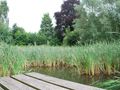
Near the center of St.-Antelinks, borough of Herzele, is somewhat hidden in a bowl-shaped valley, the beautiful Duivenbos. An old spring forest, adjacent to a quiet area and surrounded by an intact agricultural landscape. In the spring you will find beautiful carpets of wild garlic and forest anemone. The former Nature Reserves, now Natuurpunt, is building a reserve here.
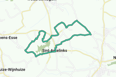
1. You can easily park your car at the church. Walk next to the church in the Ransbeekstraat - which is the extension of the Langestraat - in the direction of Steenhuize-Wijnhuize. After only 100 m you have a wide view of the rolling landscape of the Flemish Ardennes on the left. Ignore the Guchterstraat on the left and go straight ahead, direction Sint-Lievens-Esse. On the left you see the Hof te Ransbeek, a farm that was already mentioned in the Middle Ages and belonged to the abbey of Nivelles. On the right you see a few hollow roads with information signs about the Duivenbos. Follow the asphalt road and about 500 m further you turn right into the Zavelstraat, still direction St.-Lievens-Esse. On the right you have a beautiful view of the Duivenbos and the surrounding meadows. After 500 m turn right. Another 200 m further, just before a farm and again at an information board of Natuurpunt, take a field road on the right. After 30 m of asphalt, the road becomes unpaved. 300 m further you come to the Ransbeek. Continue straight into the wet to very wet and narrow, hollow road.
2. Back on the concrete road, turn right. 200 m further at the fork (Kokkestraat) you choose the right again (sign Amalrikroute + Mollestraat) and after approx. 500 m you arrive in the Kauwstraat. Go to the right and right over the old brickyard, a real piece of industrial archaeology, turn right (sign Sint-Lievenswandelroute) into a field road. Follow the small white hexagonal signs with red square. The field road runs next to a typical trouser forest and brings you to a damp hay meadow with information board. The local Natuurpunt department manages the pasture with extensive mowing management and post-grazing by cattle. All around you will find brambles, hawthorn, cherry, dogwood, cardinal's hat and elm. Acorn mouse, yellow bunting, alpine water salamander and orange tip (butterfly) feel at home here and the fox also makes an appearance there. On a path up with poplars on the left and barbed wire on the right, you go straight ahead, where the white signs with red square go to the right. After 200 m perpendicular to the right and immediately to the left again. Back on the main track, turn left and immediately right. This is the Sint-Antelinksstraat towards Herzele. Barely 50 meters further you go to the right again. You are now in the Mutsaardstraat. 350 m further you leave the concrete road for a field road on the left. Soon you have a beautiful view of Woubrechtegem. The field road bends to the right and after 400 m at the T-junction turn right again. You walk around the Hof in Roeselare, already mentioned in 1002. On the asphalt road you turn left and 50 m further you leave the Mutsaardstraat on the right and walk into the Kamstraat. On the right is a Chapel of Our Lady from 1877 with a real folk Stations of the Cross with black and white prints.
3. Another 50 m further you will see the restored mill Ter Rijst on the right. It dates from the 15th century and is protected, but fell over in 1976. Immediately after the mill turn right into the field road. Here too you can enjoy the wide panorama and a curious solitary knotlinde, a real giant candlestick. Ignore all side roads. If after 1 km the buildings start again, do not take the Wijwaterstraatje on the right, but the unpaved field road right next to it. After about a km, it takes you back into a forest and 300 m further back on the asphalt road. To the right and immediately to the left again into a wide field road. After 100 m at the fork to the left. In front of you you can already see the church of Sint-Antelinks. After approx. 700 m you will return to the concrete road. Turn left and, after one more turn to the right and one to the left, walk straight towards the village church. Take a look inside the church. It seems that this classicist St. Gertrude's church has the most beautiful interior of all Herzeelse churches.
Route navigieren in...
![]() RouteYou-App Öffnen
RouteYou-App Öffnen
Diese Werbung nicht mehr anzeigen?
→ Jetzt upgraden
![]()
Bitte warten Sie, die Navigation wird vorbereitet.
Sie können jetzt navigieren. Viel Routen-Spaß!
Bearbeitung Ihrer Anfrage ist fehlgeschlagen. Bitte versuchen Sie es erneut.
Diese Werbung nicht mehr anzeigen?
→ Jetzt upgraden
![]()
Bitte warten Sie, Ihr Download wird vorbereitet.
Ihr Download ist fertig. Viel Routen-Spaß!
Bearbeitung Ihrer Anfrage ist fehlgeschlagen. Bitte versuchen Sie es erneut.
Diese Werbung nicht mehr anzeigen?
→ Jetzt upgraden
![]()
Bitte warten Sie, Ihr Ausdruck wird vorbereitet.
Ihr Ausdruck ist bereit für den Download. Viel Routen-Spaß!
Bearbeitung Ihrer Anfrage ist fehlgeschlagen. Bitte versuchen Sie es erneut.
Diese Werbung nicht mehr anzeigen?
→ Jetzt upgraden
![]()
Bitte warten Sie, Ihr Download wird vorbereitet.
Ihr Download ist fertig. Viel Routen-Spaß!
Bearbeitung Ihrer Anfrage ist fehlgeschlagen. Bitte versuchen Sie es erneut.
<iframe src="https://plugin.routeyou.com/routeviewer/free/?language=de&params.route.id=5295230&params.language=en" width="100%" height="600" frameborder="0" allowfullscreen></iframe>
<a href="https://www.routeyou.com/en-be/route/view/5295230/recreational-walking-route/sint-antelinks-and-the-duivenbos?utm_source=embed&utm_medium=article&utm_campaign=routeshare" title="Sint-Antelinks and the Duivenbos - RouteYou" target="_blank"><img src="https://image.routeyou.com/embed/route/960x670/5295230-en@2x.png" width="960" height="670" alt="Sint-Antelinks and the Duivenbos"></a>
Zusätzliches Feedback:
Probieren Sie diese Funktionalität kostenlos mit einem RouteYou Plus-Probeabonnement.
Wenn Sie bereits ein solches Konto haben, melden Sie sich jetzt an.
Probieren Sie diese Funktionalität kostenlos mit einem RouteYou Premium-Probeabonnement.
Wenn Sie bereits ein solches Konto haben, melden Sie sich jetzt an.
© 2006-2024 RouteYou - www.routeyou.com