4064 Aufrufe | Öffentlich | Niederländisch
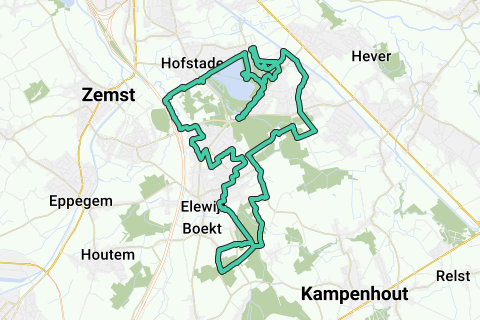
This trail/MTB loop runs integrally on the east side of the E19 in Zemst. I checked this loop from the Info board that is located in Hofstade at the Sports Hall / Swimming Pool of the BLOSO. It is the blue loop, supplemented by a red southern extension to the Snijsselsbos: https://www.routeyou.com/nl/location/view/47931325/informatiebord-mtb-lussen-zemst-in-hofstade-hier-komt-de-blauwe-en-rode-mtb-lus-langs.nl
The blue and red loop drawn on the information board is wrong in several places (impermeable pieces). If you follow the blue and red arrows in the field in 'counter-clockwork', and they have not disappeared (which happens too much), then you still get stuck south of the Snijsselsbos (no more signs) Therefore, use this GPS routing.
On the site of Mountainbike Routes ( http://www.mtbroutes.be/routedetail.php?id=221 ) there are the same routing errors in the GPX of this blue and the red loop.
SO: ALSO NOTE THAT THERE IS NOT YET ANY SIGNAGE OF THE RED EXTENSION IN STEENOKKERZEEL AND KAMPENHOUT! (October 2014). So if you still want to follow the counterclockwork pointer signaling, skip the red extension; or buy a map and know that certain routes are a bit wrong; or take this correct GPX, or print the RouteYou card of this GPX to your printer.
The loop presented here is 100% correct (which is very important for trail runners), runs in 'clockwork clockwise' (so you won't find any clues along the way and you don't have to rely on it), and it starts at the sports hall/swimming pool of the Bloso in Hofstade (Zemst).
This loop in clockwork direction has an overlap of 150m on 1 small piece at the Sportimonium (Blosodomein Hofstade). There are no other overlaps (there are) because this GPX always goes 'right' to an overlap. As a result, at the blue inner loop in the Bloso domain, the southern and northern walking/cycling directions temporarily follow the measured route direction.
Take a look at the photos of the POIs (they are all on the trail) so you have an idea of what to expect.
The blue loop takes an 'infill' in the Bloso domain (see below) and enters Schiplaken (Boortmaarbeek). The red loop does not take the infill in the Bloso domain, but does include the Snijsselsbos and Vossenkot in the south (Perk/Steenokkerzeel).
This Blue-Red loop contains both the blue infill in the Bloso domain and the red extension in the south. With this GPS, which is 100% correct, you can skip both the infill loop and the expansion loop if desired (see below).
For the trail runners some features of the integral loop:
Real walking distance = 26,3km
Distance paved = 11km (42%)
Distance paved (dolomite, embers, cobblestone edm) = 4,3km (16%)
distance unpaved = 11km (42%)
The part in the Bloso domain (6.8km of which 2.7km (40%) paved and 4.1km (60%) unpaved) contains the most unpaved strips. These are located on the eastern side of the easternmost pond, and just north of the busy northeastern Molenheidebaan between the southernmost and the eastern parking lot under the ringggracht.
The other parts contain quite a lot of asphalt and paved surface, so you can easily walk down this loop with regular running shoes.
Two strips are still in the original cobblestone strip: In Perk/Steenokkerzeel (southwest between Hoogstraat and Boektsestraat) the east-west Driebundersweg, and in Schiplaken (east) the north-south Gottendijsdreef. Difficult to ride and walk!
Also beware of the narrow and busy Kampenhoutsebaan, where the cars sometimes drive much too fast.
Blue infill loop: Between the railway line 27b and the Bloso ponds in the Bloso domain, a blue 'inner loop' extension of 5.6 km has been measured. You can skip this inner loop according to your own preference and time use, but here there is 4.5 km (80% of the infill) unpaved, and the other 1.1 km paved. At that point, follow the railway line 27b and do not go south between the first 2 narrow ponds.
Red extension loop: You can easily skip the southern red extension of 8.4 km by crossing the Kampenhoutsebaan (Vinnestraat in) south of the Schiplakenbos-Schiplakenkasteel south of the Schiplakenbos-Schiplakenkasteel and not taking the Southern Snijsselsbos. 200m further you then connect back to the blue loop.
Good luck MTB'ers, TRAILlopers and hikers who are considering walking (part of) this loop!
Route navigieren in...
![]() RouteYou-App Öffnen
RouteYou-App Öffnen
Diese Werbung nicht mehr anzeigen?
→ Jetzt upgraden
![]()
Bitte warten Sie, die Navigation wird vorbereitet.
Sie können jetzt navigieren. Viel Routen-Spaß!
Bearbeitung Ihrer Anfrage ist fehlgeschlagen. Bitte versuchen Sie es erneut.
Diese Werbung nicht mehr anzeigen?
→ Jetzt upgraden
![]()
Bitte warten Sie, Ihr Download wird vorbereitet.
Ihr Download ist fertig. Viel Routen-Spaß!
Bearbeitung Ihrer Anfrage ist fehlgeschlagen. Bitte versuchen Sie es erneut.
Diese Werbung nicht mehr anzeigen?
→ Jetzt upgraden
![]()
Bitte warten Sie, Ihr Ausdruck wird vorbereitet.
Ihr Ausdruck ist bereit für den Download. Viel Routen-Spaß!
Bearbeitung Ihrer Anfrage ist fehlgeschlagen. Bitte versuchen Sie es erneut.
<iframe src="https://plugin.routeyou.com/routeviewer/free/?language=de&params.route.id=1939312&params.language=en" width="100%" height="600" frameborder="0" allowfullscreen></iframe>
<a href="https://www.routeyou.com/en-be/route/view/1939312/mountain-bike-route/mtb-zemst-blue-red-mtb-loop-zemst-steenokkerzeel-kampenhout-boortmeerbeek?utm_source=embed&utm_medium=article&utm_campaign=routeshare" title="MTB ZEMST : Blue-Red MTB loop (Zemst-Steenokkerzeel-Kampenhout-Boortmeerbeek) - RouteYou" target="_blank"><img src="https://image.routeyou.com/embed/route/960x670/1939312-en@2x.png" width="960" height="670" alt="MTB ZEMST : Blue-Red MTB loop (Zemst-Steenokkerzeel-Kampenhout-Boortmeerbeek)"></a>
Zusätzliches Feedback:
Probieren Sie diese Funktionalität kostenlos mit einem RouteYou Plus-Probeabonnement.
Wenn Sie bereits ein solches Konto haben, melden Sie sich jetzt an.
Probieren Sie diese Funktionalität kostenlos mit einem RouteYou Premium-Probeabonnement.
Wenn Sie bereits ein solches Konto haben, melden Sie sich jetzt an.
© 2006-2024 RouteYou - www.routeyou.com