3158 Aufrufe | Öffentlich | Französisch • Niederländisch
Course of Flanders 2013-04-28: http://sport.be.msn.com/loopvanvlaanderen/2013/nl/
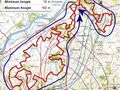
The starting and ending point is located on the Oudenaarde Market at an altitude of 11m.
This GPS routing was created based on the exact GPX recording with my GPS and some minor tweaks on the latest NGI digital topographic maps showing trails and terrain trails. The trail is not 50 km (officially) long but 51 km. And the altimeters to overcome are 930 meters for the whole loop.
Taking into account the added differences in NGI topographic height (about 930 meters), the walking distance (actual on slopes) is 51.18 km. See also the first POI at the start (Markt Oudenaarde) for these values and an image of the concrete height profile according to the loop to be travelled.
The trail consists largely of paved/paved/paved roads/paved strips, with also many forest trails and fields. The sloping rooms in the last part are mostly unpaved. The 51 km loop is therefore located in the heart of the Flemish Ardennes (with all known calf biters on the menu) and designed as part of the Trail.
Many exceptionally beautiful views can be admired during this loop.
Beyond the Scheldt at Oudenaarde, the following Flemish tracks are on the menu in order (some are traversed/walked along different flanks; each arrow shows a descent along a valley of a river):
--> Achterberg, Ladueze,
--> Eikenberg,
--> Bossenare (in part),
--> Koppenberg (1),
"> Onderbos,
--> Koppenberg (2),
--> Kwaremont (1),
"> Feelbos,
--> Kwaremont (2),
--> Paterberg (1),
--> Carillon-Chaux kiln near Paterberg (2),
--> Fonteinbos and Nophove,
--> (alongside Hoogberg),
--> Kabernol (Smisstraat),
--> Kortekeer (Nukerke),
--> Koppenberg (3).
The Flemish Ardennes at its best!
Route navigieren in...
![]() RouteYou-App Öffnen
RouteYou-App Öffnen
Diese Werbung nicht mehr anzeigen?
→ Jetzt upgraden
![]()
Bitte warten Sie, die Navigation wird vorbereitet.
Sie können jetzt navigieren. Viel Routen-Spaß!
Bearbeitung Ihrer Anfrage ist fehlgeschlagen. Bitte versuchen Sie es erneut.
Diese Werbung nicht mehr anzeigen?
→ Jetzt upgraden
![]()
Bitte warten Sie, Ihr Download wird vorbereitet.
Ihr Download ist fertig. Viel Routen-Spaß!
Bearbeitung Ihrer Anfrage ist fehlgeschlagen. Bitte versuchen Sie es erneut.
Diese Werbung nicht mehr anzeigen?
→ Jetzt upgraden
![]()
Bitte warten Sie, Ihr Ausdruck wird vorbereitet.
Ihr Ausdruck ist bereit für den Download. Viel Routen-Spaß!
Bearbeitung Ihrer Anfrage ist fehlgeschlagen. Bitte versuchen Sie es erneut.
<iframe src="https://plugin.routeyou.com/routeviewer/free/?language=de&params.route.id=701042&params.language=en" width="100%" height="600" frameborder="0" allowfullscreen></iframe>
<a href="https://www.routeyou.com/en-be/route/view/701042/jogging-route/promenade-des-flandres-51km?utm_source=embed&utm_medium=article&utm_campaign=routeshare" title="Promenade des Flandres (51km) - RouteYou" target="_blank"><img src="https://image.routeyou.com/embed/route/960x670/701042-en@2x.png" width="960" height="670" alt="Promenade des Flandres (51km)"></a>
Zusätzliches Feedback:
Probieren Sie diese Funktionalität kostenlos mit einem RouteYou Plus-Probeabonnement.
Wenn Sie bereits ein solches Konto haben, melden Sie sich jetzt an.
Probieren Sie diese Funktionalität kostenlos mit einem RouteYou Premium-Probeabonnement.
Wenn Sie bereits ein solches Konto haben, melden Sie sich jetzt an.
© 2006-2024 RouteYou - www.routeyou.com