1144 Aufrufe | Öffentlich | Niederländisch
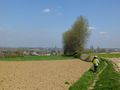
Idea for a walk in the Flemish Ardennes: step along the banks of the Zwalm and the Miners' Path. Where they intersect, you can stop for a drink on the terrace of the Boembekemolen.
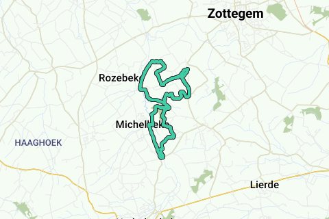
Over 22 km, from the Brakelbos to the Scheldt, the Zwalm winds through often untouched pieces of nature and past numerous water mills. On our route we pass the Boembekemolen, managed by Natuurpunt. We walk mostly on narrow and sometimes marshy paths, field roads and the Miners' Path, a beautiful straight cycling and walking path over the old railway line that used to take the Flemish miners from Zottegem to the Borinage. The former station of Michelbeke and an old cow bridge are still relics of that time. Our route uses the new walking network 'Zwalm'. Since there are many path changes, it is important to closely follow the indications from node to node. Sturdy and waterproof footwear is a requirement, especially after a lot of rainfall.
-----------------
The route
-----------------
Departure parking Riedeplein 1 in Michelbeke, near the former station (1). At Groenstraat RA. After 40 m you will arrive at KP44 – RD to KP43 (over Zwalmbrugje) – LA path along Zwalm to KP45. Path RA to FP46. LA to FP47, which you reach after 200 m. RA to FP48 and again RA to FP49. Follow RD road to FP50, to St.-Goriksstraat RD and almost immediately LA to KP50. 50 m past KP50 rising field road diagonally left to KP54 - to T RA and to the main road to chapel with crucifix LA. Just past house no. 7 (approx. 100 m before the church of St.-Goriks-Oudenhove (2) and café) you come to KP54 – veldweg LA to KP55 (café de Zavelput) – 50 m RD to KP56 /Shortening min 2 km: to KP56 RD to KP57 and then LA to KP58 (narrow path along hedge) - on street road even RA and on KP58 LA the normal route to KP47 // On KP56 veldweg RA to KP60. Here (just before farm) RA tile path to FP64. On asphalt RD to farm (FP64). LA to FP63 - beyond homes RA, then for white house path LA to FP63. You go over the cow bridge (3) and then immediately 180° LA over steps to the Miners' Path (KP63), which follows your RA until KP61. RD to FP57. Attention: where the arrow to FP57 on the left leaves the Miners' Path, you stay on it and leave the junctions for a while. On street road LA. You will pass the Boembekemolen (4). 100 m further you arrive at FP58 (meeting with shortening) and follow the walking network again. On FP58 field road RA to KP47 and further RD to FP46. Here here just RD to FP38 and after 50 m RA. Closely follow fp38 designations. On asphalt (Berendries) LA, then (just past tavern Stappersalm) RA to KP38. Extension + 2 km: turn left at FP38 and follow to FP39. At KP39 RA alley between the houses to KP40 - this alley turns into a path - to major road RA and a little further (to KP40) again RA over the Miners path to KP44. LA to the car park.// On KP38 narrow path RA between the houses to KP43 - follow on asphalt on the right. At T (Berendries) LA to KP43 (Zwalmbrugje). RD to FP44. RD – 40 m further you will arrive at the parking.
Route navigieren in...
![]() RouteYou-App Öffnen
RouteYou-App Öffnen
Diese Werbung nicht mehr anzeigen?
→ Jetzt upgraden
![]()
Bitte warten Sie, die Navigation wird vorbereitet.
Sie können jetzt navigieren. Viel Routen-Spaß!
Bearbeitung Ihrer Anfrage ist fehlgeschlagen. Bitte versuchen Sie es erneut.
Diese Werbung nicht mehr anzeigen?
→ Jetzt upgraden
![]()
Bitte warten Sie, Ihr Download wird vorbereitet.
Ihr Download ist fertig. Viel Routen-Spaß!
Bearbeitung Ihrer Anfrage ist fehlgeschlagen. Bitte versuchen Sie es erneut.
Diese Werbung nicht mehr anzeigen?
→ Jetzt upgraden
![]()
Bitte warten Sie, Ihr Ausdruck wird vorbereitet.
Ihr Ausdruck ist bereit für den Download. Viel Routen-Spaß!
Bearbeitung Ihrer Anfrage ist fehlgeschlagen. Bitte versuchen Sie es erneut.
Diese Werbung nicht mehr anzeigen?
→ Jetzt upgraden
![]()
Bitte warten Sie, Ihr Download wird vorbereitet.
Ihr Download ist fertig. Viel Routen-Spaß!
Bearbeitung Ihrer Anfrage ist fehlgeschlagen. Bitte versuchen Sie es erneut.
<iframe src="https://plugin.routeyou.com/routeviewer/free/?language=de&params.route.id=5121751&params.language=en" width="100%" height="600" frameborder="0" allowfullscreen></iframe>
<a href="https://www.routeyou.com/en-be/route/view/5121751/recreational-walking-route/along-the-early-zwalm?utm_source=embed&utm_medium=article&utm_campaign=routeshare" title="Along the Early Zwalm - RouteYou" target="_blank"><img src="https://image.routeyou.com/embed/route/960x670/5121751-en@2x.png" width="960" height="670" alt="Along the Early Zwalm"></a>
Zusätzliches Feedback:
Probieren Sie diese Funktionalität kostenlos mit einem RouteYou Plus-Probeabonnement.
Wenn Sie bereits ein solches Konto haben, melden Sie sich jetzt an.
Probieren Sie diese Funktionalität kostenlos mit einem RouteYou Premium-Probeabonnement.
Wenn Sie bereits ein solches Konto haben, melden Sie sich jetzt an.
© 2006-2024 RouteYou - www.routeyou.com