2294 Aufrufe | Öffentlich | Französisch • Niederländisch
Distance:
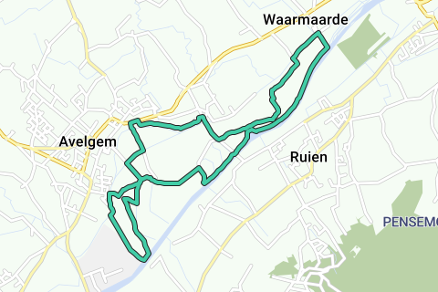
1: Blue Walk (from 1 to 12): 12.5 km
2: Blue-orange walk (short version from 1 to 8, then via the Prairie up to 12): 6 km
In addition, there is also a variant provided directly through the Scheldemeersen (only in dry weather) - the blue-green promenade.
Paving: Alternating paved and unpaved roads. Dogs kept on a leash.
Departure: Meerstraat 43 (Pattijne-Duprez company). Here is a spacious car park.
Accessibility: SNCB: train to Kortrijk, from there bus lines 91 and 92, bus stop Avelgem station + 10 min. steps via the Meerstraat.
Bicycle junction: Near Bicycle Junction 9.
1.We start at Meerstraat 43 (Pattijne-Duprez Company) with parking. A little further towards the Scheldt, we come to the name "deweer". Through a door we enter the Natuurpunt Avelgem estate. On the left is the nature class.
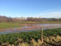
We follow the old arm of the Scheldt on the right with its water lilies, yellow plomp, crested duck and kingfisher, towards the Scheldt.
2. Once outside the estate (with a swinging door), we find situations of puddles and wetlands with pastures to the left of the road, laid out during the recent nature development project and good for waterfowl, amphibians and wading birds. At the end of this dirt road, we turn right towards the newly built bicycle and pedestrian bridge.
3. To the right of it, we climb the old railway embankment 'the Trimaarzate',
The Kortrijk-Ronse-Bergen railway line was opened in 1869, mainly for commuting to the Walloon coalfield. We follow the last 800 meters of the railway, an exceptional biotope with behind us a surprisingly beautiful and elevated view of the Scheldt and the Kluisberg behind. On the old railway bridge, there is a native forest on the left in what remains of the "Schalaffiemeersen" stolen by industry.
4. On the bridge we take the stairs to the right and follow the Rijt to the Meersstraat. Follow the Meersstraat on the right and turn left a little further into the Harentstraat until you reach the Scheldelaan (bed and breakfast 'De Karekiet').
5. Follow the Scheldt left until the next Rijtbrug. Take the unpaved path to the right after the bridge, along the Rijt to the Kareelovenstraat.
A charstilt stone is a stone full of clay, fired in the open air, which has been fired outdoors in country ovens. Between the unfired stones ("raw brieken"), coal-filled heating channels were provided. Once there was enough fire, up to six layers of clay-formed stones were imposed. This pile was then closed with old stones and walled with clay. Such a field oven was then built daily at a height of six meters. The temperature exceeded 1000 °C and the cooking process lasted about 10 days.
Follow Kareelovenstraat on the left until you reach Oudenaardsesteenweg.
6. On the Oudenaardsesteenweg ('N8'), turn right, after 50 m, turn right into the small street on the right.
In front of you is 'het Elzenbroek'; a rough with layers of well-developed grasses and shrubs. It is also a municipal birth plantation. Now follow the Ruggekouterweg, a good example of what a slow road can mean, a quiet, safe and short connection between the center of Avelgem and the center of Rugge. Follow this unpaved Ruggekouterweg after the ash 'Ter Elst' on your right.
7. The Ruggekouterweg ends at the Ruggestraat with the café "Meerschblomme" on the left.
Right in front of you, on the other side of the Ruggestraat, is the Waterhoek, known for Stijn Streuvel's work 'De teleurgang van de Waterhoek'. The Avelgemse Ruggewijk, an independent and isolated island of Avelgem for centuries that did not tolerate interference from outsiders, was disrupted in its daily life by the works on the Scheldt bridge, the connection with the Ruien of East Flanders. If you wish, you can do the 'Hiking between the Bergkouter and the Ruggemeers' as an additional loop. Frans De Leersnijder described this walk in the spring issue of Ivy in 2015.
We follow the Ruggestraat on the right towards Scheldebrug, namely De Mirabrug.
8. In front of the Scheldebrug, near the Ronnemontstraat, we turn left into the Meersen district the Ruggemeersen. Just like the Sea Scheldt, this area is good for unique vegetation. An open landscape, originally heavily fed by groundwater, characterized by many small landscape elements, pollard willows, rows of trees... Pollard willows are indispensable in the Scheldt Valley. They adorn the landscape and, due to their many natural cavities, provide an ideal breeding ground for birds such as the cave pigeon and the stone owl.
On your left, you have a view of 'de Rijt'. De Rijt, which was originally called 'de Rugge' in the 9th and 10th centuries, also gave its name to the lakes along the former 'de Ruggemeersen'. On the right we have an exceptional view of the Kluisberg which flows east to Tiegemberg.
We walk to the left of the Waarmaarde-cut-off to the Trappelstraat. This former arm of the Scheldt was purchased by the Nature and Forestry Agency with the aim of restoring it to its original state and preserving it as a valuable nature reserve. The north arm is particularly rich in fish and includes a varied aquatic flora. Different species of birds (the Great Karekiet), dragonflies and butterflies will find their ideal habitat here.
9. We continue our way along the Rijtgrachtstraat and a little further to the right along the paved and slow road towards OLV-Geboorte kerk van Waarmaarde.
This church is also called "the cathedral of the Scheldt". It is a
The most remarkable churches in the region because it consists of 2 naves. The church is protected as a monument (KB- 20/02/1939). Of this 13th century Romanesque church, the south transept and the substructure of the square celebration tower have been preserved. Other parts are Gothic. Inside there is a communion bench and a pulpit from 1634. Karel Lateur, Stijn Streuvels' brother, carved the calvary in blue stone outside the church around 1900. The church suffered in the days of May 1940. In the cemetery and along the Coulterrug, English soldiers had entrenched themselves to prevent the Germans from crossing the Scheldt. Gaps were broken in the cemetery wall and the riverside connection was destroyed. The attackers set up an emergency bridge. There was heavy shooting in the centre of the village. The British fallen are buried in the cemetery. After the war, the roof of the pointed tower was replaced with a more blunt cladding. Due to the war damage of World War I and World War II, the church was in need of extensive repair and reconstruction work.
10. From OLV Street we go south to the banks of the Scheldt which we follow on the right
direction Avelgem. Beyond the bridge is 'la Mira-coupure' on the right. The nature development project of the West Flemish Scheldt has profoundly changed the appearance of the "Bekaert cut" originally mentioned here. This has been transformed into a single whole, which in the long term offers more possibilities for better water quality and therefore aquatic life.
With the successful purchase of the inner area of the meander, a peninsula was formed with reeds and various wet/dry roughs.
11. At 100 meters after 'le Mira-coupure', we follow the path on the right along 'de Prairie-coupure' to the Ronnemont which we follow on the left to the bed and breakfast 'De Karekiet'. On the way, we meet 'de Vuile-coupure' on the left of the road below the meadow. After the straightening of the Scheldt, it served as a dump. Half was filled, then covered with earth and used as pasture. In consultation with the VLM and given the high clean-up costs, little was changed during the implementation of the nature conservation project.
12. After the Karekiet, we follow the denomination on the left at the Café 'Het Zakske'. At the end of this name, we return to a swing gate on a paved road that we follow on the right to the Patijne-Duprez car park.
Shorter variant
TO 8. We now turn right into Ronnemont Street, after the Mira name, towards the old Prairie. We continue our walk to the starting point.
Variant directly through the Scheldemeersen - only in dry weather
Start at 1 and go straight to 12.
TO 12. We follow the Ronnemont and turn left into the Kareelovenstraat. A few hundred meters further, in the Kareelovenstraat, we turn right onto a grassy road in the Meersen. We arrive at a meadow gate with passage for hikers and go straight through the meadow. Warning: in wet weather this place is practically inaccessible.
Finally, we reach a ditch that we cross on a narrow bridge. We follow the ditch on the left to the Rijtgracht which we follow on the right to a concrete bridge.
We cross the Rijt and continue straight along the Bosje Ter Elst to the Ruggekouterweg.
We arrive between numbers 6 and 7 on the map and continue the walk to the Ruggestraat on the right.
Thanks to the late Frans Dejonghe who made us discover the passion for such walks. French, we will continue.
This promenade was designed by Jean-Pierre Christiaens and has already appeared in Ivy 2016-2. The photos are by Jean-Pierre Christiaens and Francis Pattyn.
Ivy is the magazine member of Natuur.koepel asbl. More info: http://www.natuurkoepel.be
Route navigieren in...
![]() RouteYou-App Öffnen
RouteYou-App Öffnen
Diese Werbung nicht mehr anzeigen?
→ Jetzt upgraden
![]()
Bitte warten Sie, die Navigation wird vorbereitet.
Sie können jetzt navigieren. Viel Routen-Spaß!
Bearbeitung Ihrer Anfrage ist fehlgeschlagen. Bitte versuchen Sie es erneut.
Diese Werbung nicht mehr anzeigen?
→ Jetzt upgraden
![]()
Bitte warten Sie, Ihr Download wird vorbereitet.
Ihr Download ist fertig. Viel Routen-Spaß!
Bearbeitung Ihrer Anfrage ist fehlgeschlagen. Bitte versuchen Sie es erneut.
Diese Werbung nicht mehr anzeigen?
→ Jetzt upgraden
![]()
Bitte warten Sie, Ihr Ausdruck wird vorbereitet.
Ihr Ausdruck ist bereit für den Download. Viel Routen-Spaß!
Bearbeitung Ihrer Anfrage ist fehlgeschlagen. Bitte versuchen Sie es erneut.
Diese Werbung nicht mehr anzeigen?
→ Jetzt upgraden
![]()
Bitte warten Sie, Ihr Download wird vorbereitet.
Ihr Download ist fertig. Viel Routen-Spaß!
Bearbeitung Ihrer Anfrage ist fehlgeschlagen. Bitte versuchen Sie es erneut.
<iframe src="https://plugin.routeyou.com/routeviewer/free/?language=de&params.route.id=4498020&params.language=en" width="100%" height="600" frameborder="0" allowfullscreen></iframe>
<a href="https://www.routeyou.com/en-be/route/view/4498020/walking-route/the-avelgemse-scheldemeersen-from-east-to-west?utm_source=embed&utm_medium=article&utm_campaign=routeshare" title="The Avelgemse Scheldemeersen from east to west - RouteYou" target="_blank"><img src="https://image.routeyou.com/embed/route/960x670/4498020-en@2x.png" width="960" height="670" alt="The Avelgemse Scheldemeersen from east to west"></a>
Zusätzliches Feedback:
Probieren Sie diese Funktionalität kostenlos mit einem RouteYou Plus-Probeabonnement.
Wenn Sie bereits ein solches Konto haben, melden Sie sich jetzt an.
Probieren Sie diese Funktionalität kostenlos mit einem RouteYou Premium-Probeabonnement.
Wenn Sie bereits ein solches Konto haben, melden Sie sich jetzt an.
© 2006-2024 RouteYou - www.routeyou.com