Font: Booking.com
Drets d'autor: All rights reserved
121 visites | Pública | Espanyol
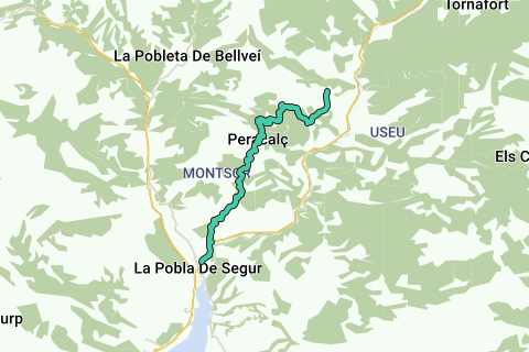
This is stage 1 of "El cinquè Llac", named "The Sleeping Giant". We set out from La Pobla de Segur, taking the N-260 road in the direction of Sort, until we get to the rest area of the Vallcarca stream (at 1 km). Here, the old Montsor path begins, which we will make a meandering ascent over old paved paths and stretches carved into the rock. The views are breathtaking: to the north, we can see Montsor and its crags with birds of prey flying overhead; to the south, Sant Antoni reservoir and the elongated mountain range of El Montsec, divided by two points that mark the two gateways to the Pallars region, the Terradets and Mont-rebei gorges. On arrival at Montsor hill, we have two options: To follow the track until we come to a point beneath the village of Montsor, from which a track emerges in the direction of the Peracalç farmhouse. To take a small path that also leads to the farmhouse. We pass over Peracalç farmhouse, crossing the village of Peracalç, to get to its mountain range, which boasts spectacular views. More intrepid hikers can venture as far as the peak known as L’Àliga (The Eagle), where they can see for their own eyes how it got its name.
We begin the descent towards the Pla de Corts plain, passing through Cortscastell, near Pujol and the stone cross, with the Sleeping Giant in the background keeping an eye on us at all times, to complete the stage on our arrival in Peramea, an important medieval walled village.
Technical specifications:
Starting – end point: la Pobla de Segur-Peramea
Points of passage: Masia de Peracalç-Peracalç-serra de Peracalç-Cortscastell-Peramea
Accommodation in Casa Parramon
Distance: 19,5 km
Elevation: +1.127 m / -759 m
Maximum altitude: 1.240 m
Minimum altitude: 530 m
Time: 6 h 15 min
Difficulty: This stage does not present any technical difficulty.
Navega per la ruta a...
![]() Aplicació RouteYou Obriu
Aplicació RouteYou Obriu
Deixar de veure aquest anunci?
→ Millorar ara
![]()
Espereu, s'està preparant la navegació.
Ara pots navegar. Diverteix-te a la carretera!
Processament de la sol·licitud ha fracassat. Si us plau, torneu a intentar.
Deixar de veure aquest anunci?
→ Millorar ara
![]()
Espereu, s'està preparant la teva descàrrega.
La teva descàrrega està llesta. Diverteix-te a la carretera!
Processament de la sol·licitud ha fracassat. Si us plau, torneu a intentar.
Deixar de veure aquest anunci?
→ Millorar ara
![]()
Espereu, s'està preparant la teva impressió.
La teva impressió està llesta per descarregar. Diverteix-te a la carretera!
Processament de la sol·licitud ha fracassat. Si us plau, torneu a intentar.
<iframe src="https://plugin.routeyou.com/routeviewer/free/?language=ca&params.route.id=4532922&params.language=en" width="100%" height="600" frameborder="0" allowfullscreen></iframe>
<a href="https://www.routeyou.com/en-es/route/view/4532922/hiking-route/el-cinque-llac-stage-1-the-sleeping-giant?utm_source=embed&utm_medium=article&utm_campaign=routeshare" title="El cinquè Llac - Stage 1: The Sleeping Giant - RouteYou" target="_blank"><img src="https://image.routeyou.com/embed/route/960x670/4532922-en@2x.png" width="960" height="670" alt="El cinquè Llac - Stage 1: The Sleeping Giant"></a>
Feedback adicional:
Proveu aquesta funcionalitat gratuïtament amb una subscripció de prova RouteYou Plus.
Si ja disposa d'aquest compte, connecteu ara.
Proveu aquesta funcionalitat gratuïtament amb una subscripció de prova RouteYou Premium.
Si ja disposa d'aquest compte, connecteu ara.
© 2006-2024 RouteYou - www.routeyou.com