15972 views | Public | Dutch
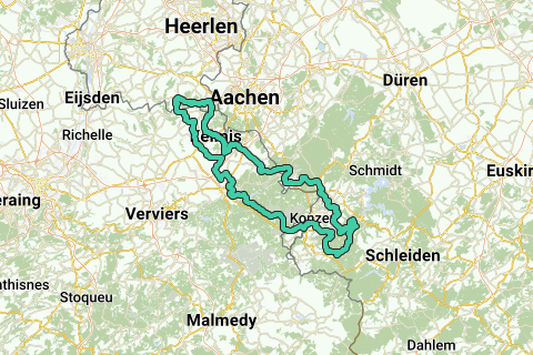
From the Vijlenerbos you cycle the route counterclockwise.
After climbing the Smidsberg, you cycle into Belgium.
Then follows the ascent of the Lattenheuer and the climb to Montzen-Gare.
Via Raborath you cycle towards Eupen, but not straight through Eupen, but in a circumferential movement. This brings you to Nispert, where a short steep climb awaits you (12%). Then you descend to the valley of the River Weser.
Now it goes 13 kilometers uphill, after passing the reservoir about 10 kilometers on roads closed to car traffic (with the exception of forestry traffic).
Eventually you reach the top of the High Fens (along the Brackvenn) at just over 600 meters altitude.
You then cycle into Germany where through roads are avoided as much as possible. You then arrive in the town of Imgenbroich where you get a steep descent of 15%, and immediately after the descent you turn right to the town of Widdau: this is a very abrupt transition, downshifting in time is recommended otherwise you will be parked on the steep climb to Widdau (and further towards Rohren). By the way, you can also choose not to turn off to Widdau, you will save yourself a steep climb and 19 kilometers.
After Rohren you quickly leave the main road, over a piece of road with some holes and crushed stone. However, then you enter the Eifel National Park: you cycle for about 10 kilometers on good asphalted roads forbidden for cars. Eventually you descend steeply to the town of Dedenborn and further towards the valley of the river Rur (which ends in the Maas near Roermond, in Dutch the river is called the Roer).
If you have skipped the climb to Widdau/Rohren, you will end up on the route again in the climb to the village of Eicherscheid . Then near Huppenbroich you get a short but steep descent (up to 16%) and also a short steep climb (up to 16%) when crossing the Tiefenbach valley.
Then you cycle towards Lammersdorf. And there you take the Vennbahn: a perfectly paved cycle path over a former railway line. You follow this cycle path for about 18 kilometers in a slightly descending direction. Only in Belgium at the town of Raeren, you leave the cycle path.
Via Eynatten and other small towns you go towards Gemmenich, where you cross the border with the Netherlands via the ascent of the Wolfhagen. Finally, the climb from the east follows the Vijlenerbos, this climb is called the Eschberg.
Navigate route in...
![]() RouteYou app Open
RouteYou app Open
Don't want to see this ad anymore?
→ Upgrade now
![]()
Please wait, the navigation is being prepared.
You can now navigate. Have fun on the road!
Processing your request has failed. Please try again.
Don't want to see this ad anymore?
→ Upgrade now
![]()
Please wait, your download is being prepared.
Your download is ready. Have fun on the road!
Processing your request has failed. Please try again.
Don't want to see this ad anymore?
→ Upgrade now
![]()
Please wait, your print is being prepared.
Your print is ready to download. Have fun on the road!
Processing your request has failed. Please try again.
Don't want to see this ad anymore?
→ Upgrade now
![]()
Please wait, your download is being prepared.
Your download is ready. Have fun on the road!
Processing your request has failed. Please try again.
<iframe src="https://plugin.routeyou.com/routeviewer/free/?language=en&params.route.id=4914766" width="100%" height="600" frameborder="0" allowfullscreen></iframe>
<a href="https://www.routeyou.com/en-nl/route/view/4914766/road-bike-route/from-south-limburg-to-the-rureifel-and-back?utm_source=embed&utm_medium=article&utm_campaign=routeshare" title="From South Limburg to the Rureifel and back - RouteYou" target="_blank"><img src="https://image.routeyou.com/embed/route/960x670/4914766-en@2x.png" width="960" height="670" alt="From South Limburg to the Rureifel and back"></a>
Additional feedback:
Try this feature for free with a RouteYou Plus trial subscription.
If you already have such an account, then log in now.
Try this feature for free with a RouteYou Premium trial subscription.
© 2006-2024 RouteYou - www.routeyou.com