The route of this road was cleaned on 28-07-2022. No idea if it is still current.
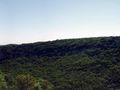
Nice walk, decent ascent and descent. This walk is recorded and traveled on map (Cévennes and Cèze Valley). The map contains about 300 km of marked hiking trails. Each junction has a name and signposts to the next nodes, between the nodes you follow the well-maintained yellow markings. Very beautiful region overlooking the valley of the Cèze.
Navigate route in...
![]() RouteYou app Open
RouteYou app Open
Don't want to see this ad anymore?
→ Upgrade now
![]()
Please wait, the navigation is being prepared.
You can now navigate. Have fun on the road!
Processing your request has failed. Please try again.
Don't want to see this ad anymore?
→ Upgrade now
![]()
Please wait, your download is being prepared.
Your download is ready. Have fun on the road!
Processing your request has failed. Please try again.
Don't want to see this ad anymore?
→ Upgrade now
![]()
Please wait, your print is being prepared.
Your print is ready to download. Have fun on the road!
Processing your request has failed. Please try again.
Don't want to see this ad anymore?
→ Upgrade now
![]()
Please wait, your download is being prepared.
Your download is ready. Have fun on the road!
Processing your request has failed. Please try again.
<iframe src="https://plugin.routeyou.com/routeviewer/free/?language=en&params.route.id=330475" width="100%" height="600" frameborder="0" allowfullscreen></iframe>
<a href="https://www.routeyou.com/en-fr/route/view/330475/recreational-walking-route/mas-le-terris?utm_source=embed&utm_medium=article&utm_campaign=routeshare" title="Mas le Terris - RouteYou" target="_blank"><img src="https://image.routeyou.com/embed/route/960x670/330475-en@2x.png" width="960" height="670" alt="Mas le Terris"></a>
Additional feedback:
Try this feature for free with a RouteYou Plus trial subscription.
If you already have such an account, then log in now.
Try this feature for free with a RouteYou Premium trial subscription.
© 2006-2024 RouteYou - www.routeyou.com