4259 views | Public | Dutch
Loop of 12 km through the Bloso domain Hofstade.
100% traffic-free, 60% in the forest, You can walk more than 90% of the roads on unpaved soil. Take advantage of trailers!
This loop is a slight extension in 2 places of the freely accessible loop of 10km:
She runs additionally through the paying beach section, and she makes a small detour in the eastern forest when going along the easternmost pond to entrance 1 (this to get to 12km loop distance)
If you take this loop outside the summer season or in bad weather, no access and identity verification is required.
If you are from the KASTZE police zone and the weather is warm: please bring your identity card. If you come from further afield, you pay for access; or take the 10km freely accessible loop.
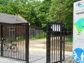
Departure and arrival of the GPS loop is near the entrance from Weerde (northwest side, on the side of the swimming pool / station of Hofstade).
Look here for the opening hours of this access: https://www.routeyou.com/location/view/47513809/noordwestingang-blosodomein-hofstade-langs-station-met-openingsuren.nl . Parking for Zemstenaars at the pool opposite this entrance. If you come from far away, take the southern or eastern parking lot.
The loop starts at the top of the recreational pond and runs in a counter-hour direction, so with the recreational pond on your left.
She passes the sailing facilities, the sports hotel and the skate facilities, where you continue to follow the large pond on the left.
At the boat restaurant (opposite a war memorial) you continue to follow the recreational pond on your left, and you take the first entrance. There you can follow the beach zone on the beach or along the bathhouse. Before the end in this paying zone (at the end) take the right and return (stay between the beach building and the canal). You leave the paying zone at the Sportimonium, and continue between the beach building and the canal to the first entrance of the beach zone to the war memorial. Continue to follow the canal on your left towards sporthotel.
There you take the left and immediately behind the canal you take the along path on the left. You follow that moat for more than 1.65 km (past a work of art, the Sportimonium and the northeast entrance), until just before the warehouses / lending service that appear on your right.
In front of this building and behind the Finse Piste, take the new path on the right towards the eastern forest behind. You are then briefly between the Finnish Piste on your right and the lending service on your left. Behind this building you come to the original path that was closed on the left by the new building. Turn right over a collection stream and follow this direction. You will come across alternating large and somewhat narrower roads / paths, occasionally quite bumpy because a part of the mountain bike piste is visited.
We take the longest possible road there without having to do a path 2x. This runs through long straights in a zigzag along the outside of the eastern forest.
If you do not use GPS for your navigation, print this route (via 'download'), and also print this POI, because you will not find a map with the correct existing paths anywhere in this eastern part:
https://image.routeyou.com/shrink/fit/1007x931/1584604e915981d75971e56e129d020d_2f7874f02254a75c6e0e7112f43975482db93398.jpg
Open this map in a separate TAB in your browser (new TAB, then copy/paste), so you can easily print it on an A4 sheet (File/print preview).
On this POI you notice that you can start the loop in 7 other places.
At the north of forest near the northeast exit, take a left and follow the railway line west to the old closure of the Bloso domain. Follow this to the left (leave the track), and follow the first rectangular pond on your left for 50m (at the bottom of the wire fence -against the pond- you can go under the outlet). In the end, this 20m walk is covered with thorn bushes, and there are some invisible pits of uprooted trees: beware. The more people who get through here, the better and easier this passage is. In the end you have to go under a gate.
Take a left there and move between the current and next rectangular pond, northward now
Repeat this 2 times (so you first walk south, then north, back south, back north (beware: narrow passage between ponds!), and then back south on the east side of the easternmost pond).
Then you follow the canal further in a northwesterly direction, and further the closure of the paying part of the domain. Then return to the starting point along the central road between the two largest ponds: Exactly 10km in the forest, a large part unpaved and traffic-free: unique in the wide surroundings of Weerde / Hofstade / Zemst / Mechelen.
Very pleasant for everyone!
If you want a different loop in this domain, take a look here (at the bottom of the map, or click on the 'Routes' tab): https://www.routeyou.com/nl/group/view/6181/blosodomein-hofstade.nl#c=50.98777299552499;4.5095050402422885&z=14
Do you want to know more about this domain? See http://www.bloso.be/centra/hofstade/Pages/Home.aspx
Navigate route in...
![]() RouteYou app Open
RouteYou app Open
Don't want to see this ad anymore?
→ Upgrade now
![]()
Please wait, the navigation is being prepared.
You can now navigate. Have fun on the road!
Processing your request has failed. Please try again.
Don't want to see this ad anymore?
→ Upgrade now
![]()
Please wait, your download is being prepared.
Your download is ready. Have fun on the road!
Processing your request has failed. Please try again.
Don't want to see this ad anymore?
→ Upgrade now
![]()
Please wait, your print is being prepared.
Your print is ready to download. Have fun on the road!
Processing your request has failed. Please try again.
Don't want to see this ad anymore?
→ Upgrade now
![]()
Please wait, your download is being prepared.
Your download is ready. Have fun on the road!
Processing your request has failed. Please try again.
<iframe src="https://plugin.routeyou.com/routeviewer/free/?language=en&params.route.id=551957" width="100%" height="600" frameborder="0" allowfullscreen></iframe>
<a href="https://www.routeyou.com/en-be/route/view/551957/walking-route/blosodomein-hofstade-12km-loop-starts-at-the-weerde-entrance?utm_source=embed&utm_medium=article&utm_campaign=routeshare" title="Blosodomein Hofstade, 12km loop, starts at the Weerde entrance. - RouteYou" target="_blank"><img src="https://image.routeyou.com/embed/route/960x670/551957-en@2x.png" width="960" height="670" alt="Blosodomein Hofstade, 12km loop, starts at the Weerde entrance."></a>
Additional feedback:
Try this feature for free with a RouteYou Plus trial subscription.
If you already have such an account, then log in now.
Try this feature for free with a RouteYou Premium trial subscription.
© 2006-2024 RouteYou - www.routeyou.com