Risorsa: Michielverbeek
Diritti d'autore: Creative Commons 3.0
3107 visite | Pubblica | Olandese
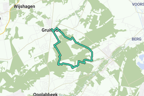
Gruitrode is located along the N730 between Opglabbeek and Bree. Except on Saturdays you can park on the Royerplein (V) at the Cultuurpunt (with food and bicycle café De Kastelein). There is also a bicycle point near the square, including map material. Starting over the asphalt of the Royestraat and past the Mariakapelletje 1 from 1927, Lourdes does not seem far away. Soon you leave the built-up area and at a junction you walk straight ahead, along with the red, yellow and blue walks. On the left you have oak trees and coniferous forest, on the right meadow and (corn) field. Once in the forest you come to a crossroads of roads. Right. You walk along the Speelbos 2. At another horse pasture you first swing along the fence, then you turn left in the direction of equestrian junction 41. At the T-junction turn left and immediately the first path on the right. No access for motorized traffic, says forest management. Horses do get through. Ignore all side paths until you come to a wide path with a paved bike lane. Turn right and then take the first path on the left, along with the red walking signs. At the wooden barrier you turn along the broom bushes to the right, to the Gruitroderheide. Soon you will see the heathland on the left. The dirt path bends to the left and you come to a crossroads of roads. Pay attention, because we will guide you through the dune area now. Walk into the area through the barrier and take the path diagonally left in front of you (the second path on your left). You turn well to the left and now follow the red and green walking signs, crossing the heath on the right. If you just walk out of the nature reserve, the red-green signs will immediately send you left back into the dunes. Keep following them, first uphill, then along the edge of the forest. At the T-junction turn right and immediately left, following the yellow walk, now towards the Oudsberg. Once again, attention has been blown through the maze of sandy paths in the heath and dune area. At the foot of the Oudsberg you follow the yellow path, first on the right and then on the left in a circumferential movement. Where the yellow path wants to take you right again, you do not follow this time. Keep walking straight ahead, soon uphill again. Do not deviate to the right. At the top you descend along a narrowing heath path to a sandy plain. You cross it and at the edge of the forest it turns left. At the T-junction you choose right and at the information board 3 about the walking area you walk straight on the yellow-red-blue path (and to equestrian junction 80). At a crossroads with two wooden weekend houses turn left, along with the yellow walk. Further on, take a moment to the right with all colors except green and then turn right to Bovenlee. On a flat gravel path past some weekend houses you come to an intersection with asphalt. Left. At the fork you follow on the right, along past the houses. The road winds a bit and at the mailbox of house number 2 you go straight on a dirt road. Just a little while and you notice that you are back on the red and orange walks. At an intersection, follow that path and then follow - straight ahead - red. At an intersection where red turns right, this time you walk straight ahead. You come to a cycle path, cross it straight ahead and follow in the direction of equestrian junction 41. Keep following this path at a bend in the road, on the right you have the forest edge, on the left a large field. At the end of that big field another intersection. Turn left, still on to junction 41. Now you choose - just before picnic area 4 - the second path on the right. Now follow the red, yellow and blue signs again. Ignore all side paths and gently bend to the right at a (sheep) meadow. At the intersection with asphalt and an information board 5 of the Regional Landscape Kempen-Maasland straight ahead. On the left are football pitches. Just before the 16th-century Commandery of the Teutonic Knights 6 - now privately owned - turn left, along with the walking signs. At the end you will recognize the Royestraat at the T-jump. Turn right until you reach the Gruitrode Culture Point and Royerplein.
Naviga nel percorso in...
![]() App RouteYou Aprire
App RouteYou Aprire
Vuoi smettere di vedere questo annuncio?
→ Upgrade ora
![]()
Attendi, la navigazione è in preparazione.
Ora puoi navigare. Buon divertimento in viaggio!
Elaborazione della richiesta non è riuscita. Si prega di riprovare.
Vuoi smettere di vedere questo annuncio?
→ Upgrade ora
![]()
Attendi, il tuo download è in preparazione.
Il tuo download è pronto. Buon divertimento in viaggio!
Elaborazione della richiesta non è riuscita. Si prega di riprovare.
Vuoi smettere di vedere questo annuncio?
→ Upgrade ora
![]()
Attendi, la tua stampa è in preparazione.
La tua stampa è pronta per il download. Buon divertimento in viaggio!
Elaborazione della richiesta non è riuscita. Si prega di riprovare.
Vuoi smettere di vedere questo annuncio?
→ Upgrade ora
![]()
Attendi, il tuo download è in preparazione.
Il tuo download è pronto. Buon divertimento in viaggio!
Elaborazione della richiesta non è riuscita. Si prega di riprovare.
<iframe src="https://plugin.routeyou.com/routeviewer/free/?language=it&params.route.id=5367081&params.language=en" width="100%" height="600" frameborder="0" allowfullscreen></iframe>
<a href="https://www.routeyou.com/en-be/route/view/5367081/recreational-walking-route/around-the-oudsberg?utm_source=embed&utm_medium=article&utm_campaign=routeshare" title="Around the Oudsberg - RouteYou" target="_blank"><img src="https://image.routeyou.com/embed/route/960x670/5367081-en@2x.png" width="960" height="670" alt="Around the Oudsberg"></a>
Altri commenti:
Prova questa funzionalità gratuitamente con un abbonamento di prova RouteYou Plus.
Se hai già un tale account, accedi ora.
Prova questa funzionalità gratuitamente con un abbonamento di prova RouteYou Premium.
© 2006-2024 RouteYou - www.routeyou.com