Source: Noorse at nl.wikipedia
Copyright: Creative Commons 3.0
1707 views | Public | Dutch
Appointment at the village church of Hulshout (V). This neo-Gothic St. Matthew's Church dates from 1893. There is ample parking in the area, but you can also get there by regular bus via line 222 (AarschotHerentals).
Walk straight across the church into Kosterstraat and continue straight for almost 1 km. Then through a barrier into the forest and after 100 m to the left. You walk here in the Herenbossen, a domain forest, owned by the Flemish Community since 1985. You will mainly find pedunculate oak, but also poplar, spruce and American oak. Along the forest path you get a sample map of native shrubs such as mountain ash, Gelderland rose and sporkehout and a little further on the left is even a plot with Scots pine and heather. Ignore all side paths on both the left and right. After 1 km, the forest road becomes a narrow path. Walk straight ahead and after 200 m also straight along the asphalt road. On the left you see a practice track for equestrian sports and a little further a picnic area. Where the asphalt road turns left 100 m further at a football square, you turn right on a wide field road and 30 m further you are on the dike along the Grote Nete. Walk to the right along the Nete and enjoy the peace, greenery and water. After almost 2 km you arrive at the Booischotse steenweg. Cross the bridge and 50 m further you can quench your thirst in the Pallieterhoeve 1. Continue walking along the Grote Nete, but now on the left bank. After a few hundred meters on the left is the castle domain Hof ter Laken 2 with an old half-timbered farmhouse near the Nete, which in the summer of 1975 formed the backdrop for the film Pallieter by Roland Verhavert after the work of Felix Timmermans.
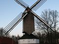
Continue walking along the Grote Nete. On and along the water you can see various birds and on and under the unpaved dike you will find tansy, queen meadows (meadowsweet), cattail, Canadian goldenrod, hogweed, Gelderland rose and much more. Their names alone are music to their ears. The view of the meadows is varied and wide. After almost 4 km you will arrive at the Herentalse steenweg. Cross it. Under the dike is café Looidijk 3, another opportunity for a refreshment. Walk over the bridge and turn right, not immediately next to the Nete but 20 m further on a wide forest road. The poorly maintained forest road runs along and under the Netedijk after 300 m and then bends to the left. This is a trouser forest, in winter or after a longer rainy period, boots are not an unnecessary luxury here. Once out of the forest, the road connects to a wider and slightly drier field road. Always keep to the left. Soon you walk between the fields and lakes with a wide view and on the right at the end the church of Hulshout as a point of reference. After about 1 km, cross the stone road and walk straight ahead in the Paardenkerkhofstraat. After 350 m, cross the Molenstraat and walk straight ahead in what is still called Paardenkerkhofstraat on the left, but Peerdekerkhofstraat (sic) on the right. On the left is the Kaasstrooimolen 4, on the border of Heist-op-den-Berg and Hulshout. The Cheese Sprinkler dates back to at least the beginning of the 15th century and was restored and festively turned in in 1990. Last summer (2011) he stood there without a cross of blades, but that should have been repaired by now. Behind the mill is a beautiful old miller's house. Walk further and turn right along with the asphalt road. Now straight ahead soon on a concrete road, but still in the Peerdekerkhofstraat. Where the concrete bends to the left, you go right before the bend into a wide earth road. The road becomes a narrow path along the hedge of the cemetery. At the entrance of the cemetery, walk to the left and then to the right in the Kerkstraat. On the Grote Baan, turn left towards the village church.
Navigate route in...
![]() RouteYou app Open
RouteYou app Open
Don't want to see this ad anymore?
→ Upgrade now
![]()
Please wait, the navigation is being prepared.
You can now navigate. Have fun on the road!
Processing your request has failed. Please try again.
Don't want to see this ad anymore?
→ Upgrade now
![]()
Please wait, your download is being prepared.
Your download is ready. Have fun on the road!
Processing your request has failed. Please try again.
Don't want to see this ad anymore?
→ Upgrade now
![]()
Please wait, your print is being prepared.
Your print is ready to download. Have fun on the road!
Processing your request has failed. Please try again.
Don't want to see this ad anymore?
→ Upgrade now
![]()
Please wait, your download is being prepared.
Your download is ready. Have fun on the road!
Processing your request has failed. Please try again.
<iframe src="https://plugin.routeyou.com/routeviewer/free/?language=en&params.route.id=5367061" width="100%" height="600" frameborder="0" allowfullscreen></iframe>
<a href="https://www.routeyou.com/en-be/route/view/5367061/recreational-walking-route/by-pallieterland?utm_source=embed&utm_medium=article&utm_campaign=routeshare" title="By Pallieterland - RouteYou" target="_blank"><img src="https://image.routeyou.com/embed/route/960x670/5367061-en@2x.png" width="960" height="670" alt="By Pallieterland"></a>
Additional feedback:
Try this feature for free with a RouteYou Plus trial subscription.
If you already have such an account, then log in now.
Try this feature for free with a RouteYou Premium trial subscription.
© 2006-2024 RouteYou - www.routeyou.com
