800 views | Public | Dutch
Want to catch a video description?
https://youtu.be/DUafNDybeJ0
If you want a shorter distance in the immediate vicinity of the Kattestraat, you can take this route of only 4.9 km:
https://www.routeyou.com/nl-be/route/view/2861412/hikingroute/kattestraat-hombeek-voetwegenlus-4-9km
If you immediately want to see the walking difficulties and easy things that you will encounter on the footpaths on the Kattestraat, first watch this video film:
https://youtu.be/534PbfaWruY
THIS DESCRIPTION IS IMPORTANT: READ THEM IN FULL!
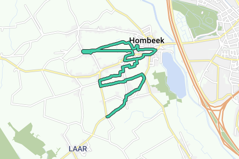
Kattestraat trail (13km of which 2.8km paved/asphalt, so this is a trail of about 80% unpaved.)
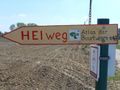
Starting from the intersection of the bend in the Humbeekseweg with the Kleine Parijsstraat (= municipal border Zemst -Laar- and Mechelen -Hombeek-) the narrow unpaved footpath 47 (Heiweg) is immediately taken in a northeasterly direction.
You can of course start your route anywhere, e.g. at the parking lot west of the railway line (north side in the center of Hombeek).
If you only take the southern side (this is a route from west to east and unturned (3x to the old Bankstraat (asphalt), and then in the opposite direction back to your starting point, then you have covered just over 8km.
If you only take the northern loop located north and south of the railway line, then this loop, without double barrel, is just over 4.5km.
So you have the free choice in your distance determination: +-4.5km, +-8km, or the entire trail of almost 13km.
The naming of this trail is inspired by the central Kattestraat, which used to be miserable (full of deep wells), and which is cut 3 times in this route to be able to follow as many unpaved traces from the Atlas der Buurtbegen as possible: in total this is a good 80% unpaved: A unique hiking, walking or mountain bike experience in the quiet nature of Hombeek.
If you want to know which neighborhood, pedestrian or actual roads you visit during this route, check out this POI in the loop: https://www.routeyou.com/nl-be/location/view/48166421/kattestraat-trail-hombeek-aanwijzing.nl . Or take the jpg here, which you can enlarge / print yourself according to your own taste: http://wmin.be/BuurtwegenAtlasZemst/Kattestaart%20trail%2013K.jpg
(Both are a 100% exact overlay of the exact recorded route (red coloring), with some main roads here and there, projected on top of the Atlas of Neighborhood Roads. If you take the jpg (with e.g. InfraView, you can zoom in at any location until you can see each atlas road with its number.
For the sake of clarity, the atlas numbering of Hombeek is attached in large on the JPG, as well as a legend with the meaning of all the paths / field roads / streets shown.
95% of this beautiful virtually car-free atlas road route can be done perfectly throughout the year. However, there are 3 points that REQUIRE DUE ATTENTION (see jpg):
1. When you cross the Kattestraat a third time, you come to the right on footpath 42, which is concreted in the beginning. Behind the garage is a closing chain that I do not know the reason for, after all it is a fairly permeable public footpath, well over private land. You can walk over it and this footpath to an end (heavy overgrowth).
Unfortunately, the last 50m this footpath 42 has also been plowed and made invisible. At that place it crossed footpath 42 with footpath 43. This footpath 43 ran diagonally from the northern intersection Middenveldweg (Buurtweg 31), which intersected behind the northern houses with footpath 41. This footpath 43 was very long and ran from the Bankstraat (where it has been shifted) through the Midenveldweg, through the Kattestraat and then to the Boterstraat. The section between the Midfield roads and Kattestraat may have been completely plowed to allow for field enlargement, which poses a second problem.
You can solve this as follows: at the end of the footpath 42 you walk between the passing perseels boundaries (preferably before sowing, or after harvesting, then no one is harmed). First it's southbound. Then we do this each time the plot boundaries make an angle of 90 °. After 4 bends and straights between the plot boundaries you will arrive at the midfield road (field path) which you follow further north.
2. The midfield road (neighbourhood road 31) and slightly more to the left footpath 36 used to run over the railway line. These two crossings were completely closed a few years ago, so that the crossing over the railway line is limited (Bakstraat (neighborhood road C3, asphalt) in the west, Hombeek center; and the eastern Schoorstraat (neighborhood road 16, asphalt on the Heike) - not counting the intermediate neighborhood road C35 akkerweg - . However, the loop can easily be short-circuited from west to east by continuing to follow the car-poor roads on the railway. After a bend to the norden (This is in fact back the neighborhood road 31 -Midfieldweg- which here the Schippersweg) you come to a T -Bosbesstraat-, which you take on the left. 30m further there is a field path on the left that takes you via a large bend to a meadow. From there you take terus footpath 36 which comes from the south of the railway line. You follow this footpath 36 along this meadow fence in the norwegian direction, and a little further, where it is sometimes plowed for 50m. You will then arrive at neighborhood road 33 which you take left to the west and continue to follow it.
3. In the Kattestraat, footpath 43 crosses from east to west. The east side has been completely plowed and built on. The west side of this footpath starts with a paved section along a recent house on the right side of this paved footpath 43: Here too, the owner, who enters you on his property, can do difficult. However, as long as you stay on the path footpath 43, this is an official public road that the municipality of Mechelen manages and the free passage is guaranteed (unless official road signs indicate otherwise).
This part of the route is usually the wettest of all. Halfway you have to cross a stream, and the next stream you have to follow west. The Voetwe 43 runs between these streams along sheep pastures. RESPECT the sealing wire so that the sheep remain in their pasture after you have passed. Respect everyone!
A nice thing about this route is that without realizing it, when you follow the northern loop, you follow the neighborhood road 31 (Middenveldweg - Schippersweg) as well as the footpath 36 on both sides of the railway line.
Note again that this is a trail road, ideal for nature walking: In the winter season there are very marshy sections - including the still existing footpath 43 between the Kattestraat and the Boterstraat; and the middle section of the plowed footpath 43 between the Midfield road and the Kattestraat-, your feet will get wet. Here, pollard willows are blown over every year in heavy winds, so you have to go around. You have to cross a narrow stream, the roadside of which is closed over a short distance: you will therefore have your hands to push the branches aside.
In addition to all these natural activities, there is also 1 very important one, they are all atlas roads that are used by nature hikers and trailopers. Always be courteous, keep the (barbed) wire or the gates closed, as they are, so that the sheep do not go their own way!
And so everyone is satisfied with this beautiful piece of car-free and quiet area in this Hombeek plateau.
Navigate route in...
![]() RouteYou app Open
RouteYou app Open
Don't want to see this ad anymore?
→ Upgrade now
![]()
Please wait, the navigation is being prepared.
You can now navigate. Have fun on the road!
Processing your request has failed. Please try again.
Don't want to see this ad anymore?
→ Upgrade now
![]()
Please wait, your download is being prepared.
Your download is ready. Have fun on the road!
Processing your request has failed. Please try again.
Don't want to see this ad anymore?
→ Upgrade now
![]()
Please wait, your print is being prepared.
Your print is ready to download. Have fun on the road!
Processing your request has failed. Please try again.
<iframe src="https://plugin.routeyou.com/routeviewer/free/?language=en&params.route.id=2895042" width="100%" height="600" frameborder="0" allowfullscreen></iframe>
<a href="https://www.routeyou.com/en-be/route/view/2895042/running-jogging-route/kattestraat-trail-13km?utm_source=embed&utm_medium=article&utm_campaign=routeshare" title="Kattestraat-trail (13km) - RouteYou" target="_blank"><img src="https://image.routeyou.com/embed/route/960x670/2895042-en@2x.png" width="960" height="670" alt="Kattestraat-trail (13km)"></a>
Additional feedback:
Try this feature for free with a RouteYou Plus trial subscription.
If you already have such an account, then log in now.
Try this feature for free with a RouteYou Premium trial subscription.
If you already have such an account, then log in now.
© 2006-2024 RouteYou - www.routeyou.com